| SIMPLEPOLYGONSYMBOL | Examples |
| <SIMPLEPOLYGONSYMBOL |
Attribute Description Table
|
|
When using ArcMap Server: boundary ="true | false" [true] boundarycolor ="0,0,0 - 255,255,255" [0,0,0] boundarytype ="solid" [solid] boundarywidth ="1 - NNN" [1] fillcolor ="0,0,0 - 255,255,255" [0,200,0] fillinterval ="2 - NNN" [6] filltype ="solid | bdiagonal | fdiagonal | cross | diagcross | horizontal | vertical" [solid] When using Image or Feature Server: antialiasing ="true | false" [false] boundary ="true | false" [true] boundarycaptype ="butt | round | square" [butt] boundarycolor ="0,0,0 - 255,255,255" [0,0,0] boundaryjointype ="round | miter | bevel" [round] boundarytransparency ="0.0 - 1.0" [1] boundarytype ="solid | dash | dot | dash_dot | dash_dot_dot" [solid] boundarywidth ="1 - NNN" [1] fillcolor ="0,0,0 - 255,255,255" [0,200,0] fillinterval ="2 - NNN" [6] filltransparency ="0.0 - 1.0" [1] filltype ="solid | bdiagonal | fdiagonal | cross | diagcross | horizontal | vertical | gray | lightgray | darkgray" [solid] overlap ="true | false" [true] transparency ="0.0 - 1.0" [no default] > No Child Elements </SIMPLEPOLYGONSYMBOL > | |
| Attribute | Usage | Back to Top |
|---|---|---|
| antialiasing | 1 Used to make edges of labels and symbols smoother. When set to "true", antialiasing is active. Note that the time to generate a map may significantly increase when antialiasing is turned on. | |
| boundary | 2 Turns boundary on or off. | |
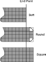
| boundarycaptype | 3 Boundary end style. |
|
| boundarycolor | 4 Boundary color using RGB values. | |
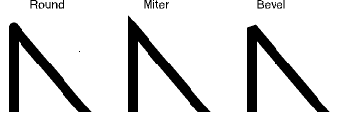
| boundaryjointype | 5 Boundary join style. |
|
| boundarytransparency | 6 Value to set percentage of transparency for the polygon boundaries. 1.0 is 0 percent transparent. 0.0 is 100 percent transparent. | |
| boundarytype | 7 Boundary type. | |
| boundarywidth | 8 Boundary width. | |
| fillcolor | 9 Fill color using RGB values. | |
| fillinterval | 10 Distance between lines for hatch fills. | |
| filltransparency | 11 Value to set percentage of transparency for the polygon fill. 1.0 is 0 percent transparent. 0.0 is 100 percent transparent. | |
| filltype | 12 Symbol fill type. | |
| overlap | 13 Determines if labels can overlap this symbol. When "true", labels can overlap. When "false", labels will not overlap the symbol. If labels are not drawing as expected, check if overlap is set to "false" for this symbol or any other symbol in the ArcIMS service. | |
| transparency | 14 Value to set percentage of transparency. 1.0 is 0 percent transparent. 0.0 is 100 percent transparent. | |
| Example 1: | Back to Top |
| <?xml version="1.0" encoding="UTF-8"?> <ARCXML version="1.1"> <CONFIG> <ENVIRONMENT> <LOCALE country="US" language="en" variant="" /> <UIFONT color="0,0,0" name="Arial" size="12" style="regular" /> <SCREEN dpi="96" /> </ENVIRONMENT> <MAP> <PROPERTIES> <ENVELOPE minx="-180" miny="-90" maxx="180" maxy="90" name="Initial_Extent" /> <MAPUNITS units="decimal_degrees" /> </PROPERTIES> <WORKSPACES> <SHAPEWORKSPACE name="shp_ws-0" directory="<path to WORLD ESRIDATA>"/> </WORKSPACES> <LAYER type="featureclass" name="CNTRY94" visible="true" id="0"> <DATASET name="CNTRY94" type="polygon" workspace="shp_ws-0" /> <SIMPLERENDERER> <SIMPLEPOLYGONSYMBOL antialiasing="true" fillcolor="255,0,0" fillinterval="8" filltype="diagcross" filltransparency="0.6" boundarywidth="4" boundarycolor="64,64,0" boundarytype="dash_dot_dot" boundarycaptype="round" boundaryjointype="bevel" boundarytransparency="0.6" boundary="true" overlap="true" /> </SIMPLERENDERER> </LAYER> </MAP> </CONFIG> </ARCXML> | |