| HASHLINESYMBOL | Examples |
| <HASHLINESYMBOL |
Attribute Description Table
|
|
antialiasing
="true | false"
[false]
color ="0,0,0 - 255,255,255" [0,0,0] interval ="0 - NNN" [8] linethickness ="1 - NNN" [1] overlap ="true | false" [true] tickthickness ="1 - NNN" [1] transparency ="0.0 - 1.0" [1.0] type ="foreground | background" [foreground] width ="1 - NNN" [6] > No child elements </HASHLINESYMBOL > | |

| Attribute | Usage | Back to Top |
|---|---|---|
| antialiasing | Used to make edges of labels and symbols smoother. When set to true, antialiasing is active. Note that the time to generate a map may significantly increase when antialiasing is turned on. | |
| color | Symbol color using RGB values. | |
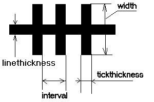
| interval | Distance between railroad crosshatches in pixels. | |
| linethickness | Line thickness in pixels. | |
| overlap | Determines if labels can overlap this symbol. When true, labels can overlap. When false, labels will not overlap the symbol. If labels are not drawing as expected, check if overlap is set to false for this symbol or any other symbol in the MapService. | |
| tickthickness | Tick thickness in pixels. | |
| transparency | Value to set percentage of transparency. 1.0 is 0 percent transparent. 0.0 is 100 percent transparent. | |
| type | If type is foreground, the symbol draws as a railroad with the crosshash. If type is background, the symbol draws as a simple line without the crosshash. | |
| width | Width of the crosshash segments in pixels. | |
| Example 1: When in CONFIG or REQUEST. | Back to Top |
| <?xml version="1.0" encoding="UTF-8"?> <ARCXML version="1.1"> <CONFIG> <ENVIRONMENT> <LOCALE country="US" language="en" variant="" /> <UIFONT color="0,0,0" name="Arial" size="12" style="regular" /> <SCREEN dpi="96" /> </ENVIRONMENT> <MAP> <PROPERTIES> <ENVELOPE minx="-124.594842" miny="24.955227" maxx="-67.672764" maxy="49.596039" name="Initial_Extent" /> <MAPUNITS units="decimal_degrees" /> </PROPERTIES> <WORKSPACES> <SHAPEWORKSPACE name="shp_ws-0" directory="<path to USA ESRIDATA>"/> </WORKSPACES> <LAYER type="featureclass" name="ROADS" visible="true" id="1"> <DATASET name="ROADS" type="line" workspace="shp_ws-0" /> <SIMPLERENDERER> <HASHLINESYMBOL color="127,227,27" linethickness="8" tickthickness="8" transparency="0.5" interval="16" width="16" type="foreground" antialiasing="false" overlap="true" /> </SIMPLERENDERER> </LAYER> </MAP> </CONFIG> </ARCXML> | |