| Using Projection Elements |

|

|
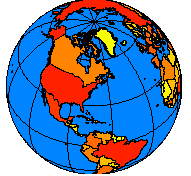
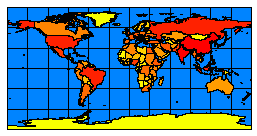
| Locations are expressed as latitude and longitude on the globe and as x- and y-coordinates on a map. | |
|
|
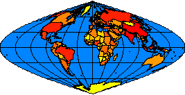
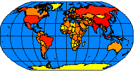
| Displaying the world using the sinusoidal projection (left) and the Robinson projection (right). | |
| Using COORDSYS in a map configuration file: |
|
<?xml version="1.0" encoding="UTF-8"?> <ARCXML version="1.1"> <CONFIG> <ENVIRONMENT> <LOCALE country="US" language="en" variant="" /> <UIFONT color="0,0,0" name="Arial" size="12" style="regular" /> </ENVIRONMENT> <MAP> <PROPERTIES> <ENVELOPE minx="-14628440.851850007" miny="-9020047.848073646" maxx="15705351.712200116" maxy="8748562.401522137" name="Initial_Extent" /> <MAPUNITS units="meters" /> </PROPERTIES> <WORKSPACES> <SHAPEWORKSPACE name="shp_ws-12" directory="c:\data" /> </WORKSPACES> <LAYER type="featureclass" name="Ocean" visible="true" id="22"> <DATASET name="WORLD30" type="polygon" workspace="shp_ws-12" /> <SIMPLERENDERER> <SIMPLEPOLYGONSYMBOL fillcolor="240,255,255" /> </SIMPLERENDERER> </LAYER> <LAYER type="featureclass" name="Robinson" visible="true" id="0"> <DATASET name="cntry94_Robinson" type="polygon" workspace="shp_ws-12" /> <COORDSYS id="54030" /> <SIMPLERENDERER> <SIMPLEPOLYGONSYMBOL filltype="solid" fillcolor="0,153,102" /> </SIMPLERENDERER> </LAYER> <LAYER type="featureclass" name="Mollweide" visible="true" id="1"> <DATASET name="Cntry94_Mollweide" type="polygon" workspace="shp_ws-12" /> <COORDSYS id="54009" /> <SIMPLERENDERER> <SIMPLEPOLYGONSYMBOL filltransparency="0.0" boundarywidth="3" boundarycolor="27,27,127" /> </SIMPLERENDERER> </LAYER> </MAP> </CONFIG> </ARCXML> |
| GET_IMAGE request with no projection elements: |
|
<?xml version="1.0" encoding="UTF-8" ?> <ARCXML version="1.1"> <REQUEST> <GET_IMAGE> <PROPERTIES> </PROPERTIES> </GET_IMAGE> </REQUEST> </ARCXML> |
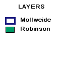
|
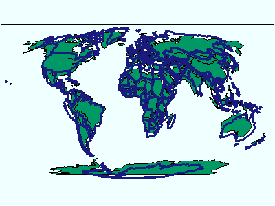
|
| GET_IMAGE request using FILTERCOORDSYS and FEATURECOORDSYS: |
|
<?xml version="1.0" encoding="UTF-8" ?> <ARCXML version="1.1"> <REQUEST> <GET_IMAGE> <PROPERTIES> <FILTERCOORDSYS id="54008" /> <FEATURECOORDSYS id="54008" /> </PROPERTIES> </GET_IMAGE> </REQUEST> </ARCXML> |

|
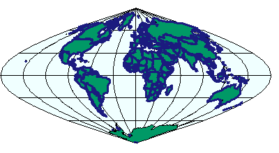
|
| GET_IMAGE request with ENVELOPE: |
|
<?xml version="1.0" encoding="UTF-8" ?> <ARCXML version="1.1"> <REQUEST> <GET_IMAGE> <PROPERTIES> <ENVELOPE minx="-14628440.851850007" miny="-9020047.848073646" maxx="15705351.712200116" maxy="8748562.401522137" /> <FILTERCOORDSYS id="54008" /> <FEATURECOORDSYS id="54008" /> </PROPERTIES> </GET_IMAGE> </REQUEST> </ARCXML> |
| IMAGE response with ENVELOPE: |
|
>?xml version="1.0" encoding="UTF8"?< >ARCXML version="1.1"< >RESPONSE< >IMAGE< >ENVELOPE minx="-14628440.85185" miny="-11510914.9347945" maxx="15705351.7122001" maxy="11239429.488243" /< >OUTPUT file="C:\ArcIMS\output\proj_paper_MYCOMPUTER79217360.jpg" url="http://mycomputer.esri.com/output/proj_paper_MYCOMPUTER79217360.jpg" /< >/IMAGE< >/RESPONSE< >/ARCXML> |

|

|
| Using FILTERCOORDSYS AND FEATURECOORDSYS in a map configuration file: |
|
<?xml version="1.0" encoding="UTF-8"?> <ARCXML version="1.1"> <CONFIG> <ENVIRONMENT> <LOCALE country="US" language="en" variant="" /> <UIFONT color="0,0,0" name="Arial" size="12" style="regular" /> </ENVIRONMENT> <MAP> <PROPERTIES> <ENVELOPE minx="-14628440.851850007" miny="-9020047.848073646" maxx="15705351.712200116" maxy="8748562.401522137" name="Initial_Extent" /> <MAPUNITS units="meters" /> <FEATURECOORDSYS id="54008" /> <FILTERCOORDSYS id="54008" /> </PROPERTIES> <WORKSPACES> <SHAPEWORKSPACE name="shp_ws-12" directory="c:\data" /> </WORKSPACES> <LAYER type="featureclass" name="Ocean" visible="true" id="22"> <DATASET name="WORLD30" type="polygon" workspace="shp_ws-12" /> <SIMPLERENDERER> <SIMPLEPOLYGONSYMBOL fillcolor="240,255,255" /> </SIMPLERENDERER> </LAYER> <LAYER type="featureclass" name="Robinson" visible="true" id="0"> <DATASET name="cntry94_Robinson" type="polygon" workspace="shp_ws-12" /> <COORDSYS id="54030" /> <SIMPLERENDERER> <SIMPLEPOLYGONSYMBOL filltype="solid" fillcolor="0,153,102" /> </SIMPLERENDERER> </LAYER> <LAYER type="featureclass" name="Mollweide" visible="true" id="1"> <DATASET name="Cntry94_Mollweide" type="polygon" workspace="shp_ws-12" /> <COORDSYS id="54009" /> <SIMPLERENDERER> <SIMPLEPOLYGONSYMBOL filltransparency="0.0" boundarywidth="3" boundarycolor="27,27,127" /> </SIMPLERENDERER> </LAYER> </MAP> </CONFIG> </ARCXML> |
| GET_IMAGE request with no projection elements: |
|
<?xml version="1.0" encoding="UTF-8" ?> <ARCXML version="1.1"> <REQUEST> <GET_IMAGE> <PROPERTIES> </PROPERTIES> </GET_IMAGE> </REQUEST> </ARCXML> |

|

|
| GET_SERVICE_INFO request: |
|
<?xml version="1.0" encoding="UTF-8"?> <ARCXML version="1.1"> <REQUEST> <GET_SERVICE_INFO fields="false" envelope="false" renderer="false" extensions="false" /> </REQUEST> </ARCXML> |
| SERVICEINFO response: |
|
<?xml version="1.0" encoding="UTF8"?> <ARCXML version="1.1"> <RESPONSE> <SERVICEINFO> <ENVIRONMENT> <LOCALE language="en" country="US" /> <UIFONT name="Arial" color="0,0,0" size="12" style="regular" /> <SEPARATORS cs=" " ts=";"/> <IMAGELIMIT pixelcount="2250000"/> </ENVIRONMENT> <PROPERTIES> <FEATURECOORDSYS id="54008" /> <FILTERCOORDSYS id="54008" /> <ENVELOPE minx="-14628440.85185" miny="-9020047.84807364" maxx="15705351.7122001" maxy="8748562.40152213" name="Initial_Extent" /> <MAPUNITS units="meters" /> </PROPERTIES> <LAYERINFO type="featureclass" visible="true" name="Ocean" id="22"> <FCLASS type="polygon"></FCLASS> </LAYERINFO> <LAYERINFO type="featureclass" visible="true" name="Robinson" id="0"> <FCLASS type="polygon"></FCLASS> </LAYERINFO> <LAYERINFO type="featureclass" visible="true" name="Mollweide" id="1"> <FCLASS type="polygon"></FCLASS> </LAYERINFO> </SERVICEINFO> </RESPONSE> </ARCXML> |
| GET_IMAGE request using FILTERCOORDSYS and FEATURECOORDSYS: |
|
<?xml version="1.0" encoding="UTF-8" ?> <ARCXML version="1.1"> <REQUEST> <GET_IMAGE> <PROPERTIES> <ENVELOPE minx="-180" miny="-90" maxx="180" maxy="90" /> <FILTERCOORDSYS id="4326" /> <FEATURECOORDSYS id="4326" /> </PROPERTIES> </GET_IMAGE> </REQUEST> </ARCXML> |

|
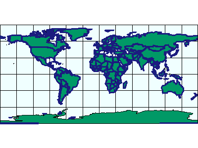
|
| GET_IMAGE request using FILTERCOORDSYS and FEATURECOORDSYS with ENVELOPE in decimal degrees: |
|
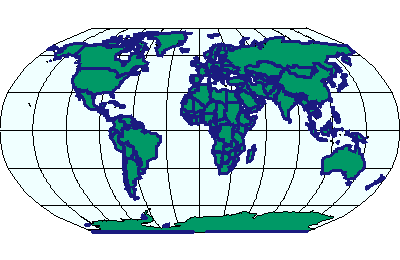
<?xml version="1.0" encoding="UTF-8" ?> <ARCXML version="1.1"> <REQUEST> <GET_IMAGE> <PROPERTIES> <ENVELOPE minx="-180" miny="-90" maxx="180" maxy="90" /> <FILTERCOORDSYS id="4326" /> <FEATURECOORDSYS id="54030" /> </PROPERTIES> </GET_IMAGE> </REQUEST> </ARCXML> |
| IMAGE response with ENVELOPE in Robinson coordinates: |
|
>?xml version="1.0" encoding="UTF8"?< >ARCXML version="1.1"< >RESPONSE< >IMAGE< >ENVELOPE minx="-16986727.8564406" miny="-12740045.8923304" maxx="16986727.8564406" maxy="12740045.8923304" /< >OUTPUT file="C:\ArcIMS\output\proj_paper_MYCOMPUTER79217360.jpg" url="http://mycomputer.esri.com/output/proj_paper_MYCOMPUTER79217360.jpg" /< >/IMAGE< >/RESPONSE< >/ARCXML> |

|
|
| Using a projection definition string for FILTERCOORDSYS AND FEATURECOORDSYS in a map configuration file: |
|
<?xml version="1.0" encoding="UTF-8"?> <ARCXML version="1.1"> <CONFIG> <ENVIRONMENT> <LOCALE country="US" language="en" variant="" /> <UIFONT color="0,0,0" name="Arial" size="12" style="regular" /> </ENVIRONMENT> <MAP> <PROPERTIES> <ENVELOPE minx="-14628440.851850007" miny="-9020047.848073646" maxx="15705351.712200116" maxy="8748562.401522137" name="Initial_Extent" /> <MAPUNITS units="meters" /> <FEATURECOORDSYS string="PROJCS["World_Robinson",GEOGCS["GCS_WGS_1984",DATUM["D_WGS_1984",SPHEROID["WGS_1984",6378137,298.257223563]],PRIMEM["Greenwich",0],UNIT["Degree",0.017453292519943295]],PROJECTION["Robinson"],PARAMETER["False_Easting",0],PARAMETER["False_Northing",0],PARAMETER["Central_Meridian",0],UNIT["Meter",1]]" /> <FILTERCOORDSYS string="PROJCS["World_Robinson",GEOGCS["GCS_WGS_1984",DATUM["D_WGS_1984",SPHEROID["WGS_1984",6378137,298.257223563]],PRIMEM["Greenwich",0],UNIT["Degree",0.017453292519943295]],PROJECTION["Robinson"],PARAMETER["False_Easting",0],PARAMETER["False_Northing",0],PARAMETER["Central_Meridian",0],UNIT["Meter",1]]" /> </PROPERTIES> <WORKSPACES> <SHAPEWORKSPACE name="shp_ws-12" directory="c:\data" /> </WORKSPACES> <LAYER type="featureclass" name="Ocean" visible="true" id="22"> <DATASET name="WORLD30" type="polygon" workspace="shp_ws-12" /> <SIMPLERENDERER> <SIMPLEPOLYGONSYMBOL fillcolor="240,255,255" /> </SIMPLERENDERER> </LAYER> <LAYER type="featureclass" name="Robinson" visible="true" id="0"> <DATASET name="cntry94_Robinson" type="polygon" workspace="shp_ws-12" /> <COORDSYS id="54030" /> <SIMPLERENDERER> <SIMPLEPOLYGONSYMBOL filltype="solid" fillcolor="0,153,102" /> </SIMPLERENDERER> </LAYER> <LAYER type="featureclass" name="Mollweide" visible="true" id="1"> <DATASET name="Cntry94_Mollweide" type="polygon" workspace="shp_ws-12" /> <COORDSYS id="54009" /> <SIMPLERENDERER> <SIMPLEPOLYGONSYMBOL filltransparency="0.0" boundarywidth="3" boundarycolor="27,27,127" /> </SIMPLERENDERER> </LAYER> </MAP> </CONFIG> </ARCXML> |

|

|
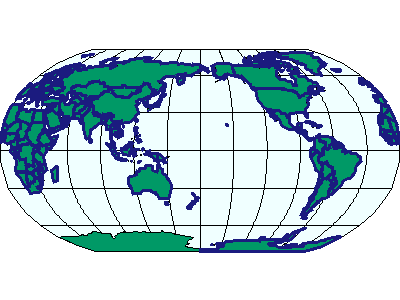
| Changing the central meridian in a projection definition string: |
|
<?xml version="1.0" encoding="UTF-8"?> <ARCXML version="1.1"> <CONFIG> <ENVIRONMENT> <LOCALE country="US" language="en" variant="" /> <UIFONT color="0,0,0" name="Arial" size="12" style="regular" /> </ENVIRONMENT> <MAP> <PROPERTIES> <ENVELOPE minx="-14628440.851850007" miny="-9020047.848073646" maxx="15705351.712200116" maxy="8748562.401522137" name="Initial_Extent" /> <MAPUNITS units="meters" /> <FEATURECOORDSYS string="PROJCS["World_Robinson",GEOGCS["GCS_WGS_1984",DATUM["D_WGS_1984",SPHEROID["WGS_1984",6378137,298.257223563]],PRIMEM["Greenwich",0],UNIT["Degree",0.017453292519943295]],PROJECTION["Robinson"],PARAMETER["False_Easting",0],PARAMETER["False_Northing",0],PARAMETER["Central_Meridian",180],UNIT["Meter",1]]" /> <FILTERCOORDSYS string="PROJCS["World_Robinson",GEOGCS["GCS_WGS_1984",DATUM["D_WGS_1984",SPHEROID["WGS_1984",6378137,298.257223563]],PRIMEM["Greenwich",0],UNIT["Degree",0.017453292519943295]],PROJECTION["Robinson"],PARAMETER["False_Easting",0],PARAMETER["False_Northing",0],PARAMETER["Central_Meridian",180],UNIT["Meter",1]]" /> </PROPERTIES> <WORKSPACES> <SHAPEWORKSPACE name="shp_ws-12" directory="c:\data" /> </WORKSPACES> <LAYER type="featureclass" name="Ocean" visible="true" id="22"> <DATASET name="WORLD30" type="polygon" workspace="shp_ws-12" /> <SIMPLERENDERER> <SIMPLEPOLYGONSYMBOL fillcolor="240,255,255" /> </SIMPLERENDERER> </LAYER> <LAYER type="featureclass" name="Robinson" visible="true" id="0"> <DATASET name="cntry94_Robinson" type="polygon" workspace="shp_ws-12" /> <COORDSYS id="54030" /> <SIMPLERENDERER> <SIMPLEPOLYGONSYMBOL filltype="solid" fillcolor="0,153,102" /> </SIMPLERENDERER> </LAYER> <LAYER type="featureclass" name="Mollweide" visible="true" id="1"> <DATASET name="Cntry94_Mollweide" type="polygon" workspace="shp_ws-12" /> <COORDSYS id="54009" /> <SIMPLERENDERER> <SIMPLEPOLYGONSYMBOL filltransparency="0.0" boundarywidth="3" boundarycolor="27,27,127" /> </SIMPLERENDERER> </LAYER> </MAP> </CONFIG> </ARCXML> |

|
|
|