
Page 35 - Local Voices, Local Choices Excerpt
P. 35
The cycles of old and new 33
Footpaths
Roads
! Houses (2017)
Gombe National Park
Village boundaries (current)
Dense Forests & Evergreen Veg. 2000 Open Woodlands and Dry Forests 2000 Non forest 1972 & 2000
Forest and Woodland Loss 1972 - 2000
BURUNDI
Data Sources: JGI, TANAPA, Maxar, OSM
Forest Cover:
Landsat MSS & ETM+ Pintea (2007)
Mapping:
Lilian Pintea / JGI
Gombe National Park
Mtanga
Kigalye
Mkongoro
Mkabogo
Kiziba
Bugamba Mwamgongo
Kagunga
Zashe
Kilemba
Mkigo Kasange
Nyarubanda Kalinzi
Bubango
Mgaraganza
Kagongo
Chankele
Bitale
Milinzi Nyabigufa
Nyamhoza Mkwanga
Kizenga Chankabwimba
Kabanga
Kwitanga Prison Forest
Matyazo
Lake Tanganyika
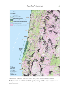
The extent of forest and woodland loss primarily outside of Gombe National Park from 1972 to 2000 (pink) along with the locations of human development.
