
Page 145 - Mapping the Nation: Taking Climate Action
P. 145
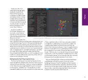
Today, even the most enduring and recognizable landmarks inside the US National Park System are vulnerable to wildfires made more destructive by climate change. Warmer winters, for example, have allowed pests to thrive and infest thousands of acres of trees—increasing potential kindling for fires across North America. As part of an effort to fortify these landmarks and structures, a small team at the National Park Service has collected data and assessed 98 percent of park structures agency-wide. The team created an interactive wildland fire risk assessment site using GIS technology. The site's GIS maps and dashboards show the threat each landmark and structure faces, and it details what can be done to achieve greater resilience. Each assessed structure, whether a historic inn or a park entrance sign, is ranked based on vulnerability and value—all visible on a map. With a clear ranking of needs, National Park Service leadership believes they can more strategically invest in efforts to reduce wildfire fuels, especially with an influx of infrastructure funding on the way. Maintaining the Past, Preserving the Future The National Park System has long maintained a facility asset management database with information about each of its built structures. But when it came to noting susceptibility to fire, there was just a single field with a yes-or-no answer to the question, "Wildfire risk?" The database was never intended to detail fire risk with information such as what kind Assessments populate a dashboard, which gives a map view of priority structures and treatment plans. of fuels might be nearby or what resources were available to firefighters for defending a structure from a wildfire. No complete spatial dataset existed for park structures yet either. If that information did exist, it was in a paper record or stored on a hard drive, not in a shared place where it could be considered in the context of the entire National Park System. There was also no accessible historical record of past assessments—those that had been made during a fire. Fires could threaten a group of structures year after year, and each time assessments would be repeated from scratch. That was all before Sarah Hartsburg and Skip Edel began cataloging about 40,000 structures across the country. Hartsburg, the project lead for the National Park Service's wildland fire risk assessments, and Edel, the National Park Service's Fire GIS program lead, thought there was a better way to collect, store, and create data about the structures available for planning and wildfire response. 144 Wildfire
