
Page 150 - Mapping the Nation: Taking Climate Action
P. 150
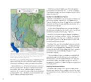
149 The Karuk Tribe's traditional territory spans 1.5 million acres. More than 98 percent of it is under the jurisdiction of the US Forest Service in the Klamath National Forest and the Six Rivers National Forest. Map courtesy of the Western Klamath Restoration Partnership. the tribe's cultural forest-burning practice helped shape the region's forests for at least a millennium before European colonization and that the forests then were more resilient. The Karuk Tribe's use of fire has connections to culture as well as sustenance. Fire revitalizes willow and hazel stands that send up fresh shoots, ideal as basketry materials. It causes the tan oak acorns to drop so they can be harvested and ground into flour. It also burns invasive plants that suck up rain and push out native food sources. "Wildfires have beneficial effects on the landscape, but some wildfires just completely wipe out all life," said Tripp. "Prescribed burning is one of the strongest tools we have to reduce fire intensity." Guiding Prescribed Burning Practices Members of the Western Klamath Restoration Partnership are working together to prepare for prescribed burning. They are using location-aware GIS applications in the field to document which trees to keep and which to cut down for a more balanced landscape. "It's also about helping the species that are suffering on the landscape and adjusting the forest to what it would have looked like culturally and historically," Tripp said. The move to cultural burning can't happen immediately because fuels have been increasing because of a fire deficit on the landscape. First, they must thin the forest, and they are using GIS analysis to make decisions about where and how they carefully crop the area. The Karuk Tribe uses GIS to map the location of culturally utilized species of plants and animals. Their data layered on GIS maps is informing adaptation strategies and was used to help craft the Karuk Climate Adaptation Plan to preserve cultural resources, promote biodiversity, and mitigate catastrophic wildfires. "The knowledge and data that are gathered by the field crews and brought into the GIS are used to understand the landscape," said Christopher Weinstein, GIS specialist with the Karuk Tribe. "This helps provide more focused management of species of interest for their revitalization and continued growth." Capturing Environmental Harm The Karuk Tribe—known as the upriver people—never left their land, despite efforts to erase and assimilate them, criminalize their culture, and extract the vital resources they rely on.
