
Page 97 - Mapping the Nation: Taking Climate Action
P. 97
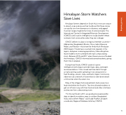
Himalayan Storm Watchers Save Lives Himalayan farmers depend on South Asia's monsoon season to drench crops and ensure their livelihood. But these storms can quickly turn from downpours to disasters, and jagged mountain ranges magnify the forces of wind and water. The International Centre for Integrated Mountain Development (ICIMOD) uses location intelligence to study weather threats and warn local communities when they are in danger. ICIMOD delivers its data to its regional member countries— Afghanistan, Bangladesh, Bhutan, China, India, Myanmar, Nepal, and Pakistan—that share the Hindu Kush Himalayan (HKH) region. Floods have occurred more regularly in the region, and given increasing populations, these disruptions leave residents more vulnerable with each compounding storm. Between 2013 and 2017, when three monsoons flooded the Himalayas, ICIMOD informed and warned residents, giving them time to prepare. During those floods, ICIMOD used its location intelligence technology to provide maps, data, and expert recommendations. It also issued real-time alerts through an early warning system operating in two areas prone to flash flooding—Assam, India, and Koshi, Nepal. Community observers use a network of transmitters to alert downstream communities when the waters rise. Many of the villages that received alerts had a seven-hour lead time before the flood hit. That time allowed residents to get out of harm's way with their livestock and other vital items and recover from a devastating storm. "For the last flood in 2017, we quickly processed satellite data to identify inundation areas in northern Bangladesh, India, and southern Nepal," said Sudip Pradhan, program coordinator, Regional Database Initiative, ICIMOD. 96 Inland Flooding
