<!-- Set the buffer around the selected feature (Belgium) -->
<LAYER type="featureclass" name="theBuffer" visible="true" id="buffer">
<DATASET fromlayer="countries"/>
<SPATIALQUERY>
<BUFFER distance="100" bufferunits="miles" />
<SPATIALFILTER relation="area_intersection">
<ENVELOPE minx="4.68" miny="50.34" maxx="5.46" maxy="50.86"/>
</SPATIALFILTER>
</SPATIALQUERY>
<SIMPLERENDERER>
<SIMPLEPOLYGONSYMBOL fillcolor="100,100,100" filltransparency="0.5" />
</SIMPLERENDERER>
</LAYER>
<!-- Select features in the target layer based on which countries fall inside the buffer -->
<LAYER type="featureclass" name="theBufferTarget" visible="true" id="buffertarget">
<DATASET fromlayer="countries"/>
<SPATIALQUERY>
<BUFFER distance="100" bufferunits="miles">
<TARGETLAYER id="countries"/>
</BUFFER>
<SPATIALFILTER relation="area_intersection">
<ENVELOPE minx="4.68" miny="50.34" maxx="5.46" maxy="50.86"/>
</SPATIALFILTER>
</SPATIALQUERY>
<SIMPLERENDERER>
<SIMPLEPOLYGONSYMBOL fillcolor="255,120,120" filltype="solid" />
</SIMPLERENDERER>
</LAYER>
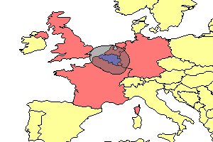 | When using the Image Server, a feature is selected and a buffer is created around the feature. Next, the target layer is applied. All features that fall within the buffer are selected. In this example, Belgium is selected and buffered 100 miles. The resulting buffer is around Belgium only. Since the countries layer is also the target layer, all surrounding countries that fall within the buffer are highlighted. |
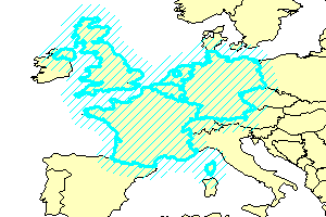 | When using the ArcMap Server, a feature is selected and a buffer is created around the feature. Next, the target layer is applied. All features that fall within the buffer are selected. The buffer is then applied to these features as well. In this example, Belgium is selected and buffered 100 miles. All countries within the 100-mile buffer are selected. The final 100-mile buffer is generated around all selected countries. The buffer in this example is represented by the diagonal lines. |