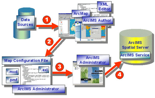
| Using Map and Viewer Configuration Files |
| Tool | File Format | File Extension | Valid ArcIMS Services |
| Author | ArcXML file | *.axl | Feature and Image Services |
| XML Editor | ArcXML file | *.axl | Feature and Image Services |
| ArcMap | ArcMap map file | *.mxd | ArcMap Image Services |
| ArcMap | Published map file | *.pmf | ArcMap Image Services |

|
| Framework of a map configuration file: |
|
<?xml version="1.0" encoding="UTF-8"?> <ARCXML version="1.1"> <CONFIG> <ENVIRONMENT>...</ENVIRONMENT> <MAP> <PROPERTIES>...</PROPERTIES> <WORKSPACES>...</WORKSPACES> <LAYER>...</LAYER> </MAP> </CONFIG> </ARCXML> |
| Prolog and ARCXML: |
|
<?xml version="1.0" encoding="UTF-8"?> <ARCXML version="1.1"> ... </ARCXML> |
| CONFIG, ENVIRONMENT, and MAP: |
|
<?xml version="1.0" encoding="UTF-8"?> <ARCXML version="1.1"> <CONFIG> <ENVIRONMENT>...</ENVIRONMENT> <MAP>...</MAP> </CONFIG> </ARCXML> |
| ENVIRONMENT and its child elements: |
|
<ENVIRONMENT> <LOCALE language="en" country="US" /> <UIFONT name="Arial" color="0,0,0" size="12" style="regular" /> <SEPARATORS cs=" " ts=";"/> <SCREEN dpi="96"/> </ENVIRONMENT> |
| MAP and its child elements: |
|
<MAP> <PROPERTIES>...</PROPERTIES> <WORKSPACES>...</WORKSPACES> <LAYER>...</LAYER> </MAP> |
| PROPERTIES and its child elements for both Feature and Image Services: |
|
<PROPERTIES> <ENVELOPE minx="-105.594842" miny="-49.955227" maxx="75.672764" maxy="83.596039" name="Initial_Extent" /> <MAPUNITS units="decimal_degrees" /> <FEATURECOORDSYS id="54008" /> <FILTERCOORDSYS id="54008" /> </PROPERTIES> |
| Using ENVELOPE: |
|
<PROPERTIES> <ENVELOPE minx="-128.1" miny="18.7" maxx="-53.7" maxy="51.3" name="Initial_Extent"/> ... <PROPERTIES> |
| Using Initial Extent and Extent Limit ENVELOPEs: |
|
<PROPERTIES> <ENVELOPE minx="-128.1" miny="18.7" maxx="-53.7" maxy="51.3" name="Initial_Extent"/> <ENVELOPE minx="-166" miny="3" maxx="-26" maxy="80" name="Extent_Limit" /> ... <PROPERTIES> |
| Using Initial Extent and Extent Limit ENVELOPEs: |
|
<SERVICEINFO> ... <PROPERTIES> <ENVELOPE minx="-120" miny="30" maxx="-100" maxy="40" name="Initial_Extent" /> <ENVELOPE minx="-140" miny="0" maxx="0" maxy="60" name="Extent_Limit" /> <MAPUNITS units="decimal_degrees" /> </PROPERTIES> ... </SERVICEINFO> |
| Viewer | How extents are used | Customizable? |
|---|---|---|
| HTML Viewer | The initial extent in the map configuration file is used by default. Different initial extents and extent limits can be set when using Designer. This information is handled by the HTML Viewer code. | Yes. See Customizing ArcIMS - HTML Viewer for more information. |
| Java Custom Viewer | The initial extent in the map configuration file is used by default. Different initial extents and extent limits can be set when using Designer. This information is handled by the Java Viewer applet. | Yes, through default.axl. See the section Default.axl: A Special Viewer Configuration File for more information. |
| Java Standard Viewer | The initial extent in the map configuration file is used and any extent limit information is ignored when using Designer. | Yes, through default.axl. See the section Default.axl: A Special Viewer Configuration File for more information. |
| ArcExplorer | The initial extent in the map configuration file is used and any extent limit information is ignored when using Designer. | No. |
| Using ENVELOPE: |
|
<PROPERTIES> <ENVELOPE minx="-61.1" miny="3.7" maxx="91.7" maxy="61.3" name="Initial_Extent" reaspect="false" /> ... <PROPERTIES> |
Reaspect set to true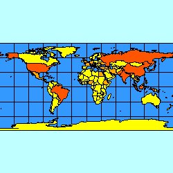
|
Reaspect set to false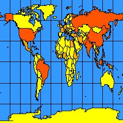
|
| PROPERTIES and its child elements valid only with Image Services (in bold): |
|
<PROPERTIES> <ENVELOPE minx="-105.594842" miny="-49.955227" maxx="75.672764" maxy="83.596039" name="Initial_Extent" /> <MAPUNITS units="decimal_degrees" /> <FEATURECOORDSYS id="54008" /> <FILTERCOORDSYS id="54008" /> <BACKGROUND... /> <LEGEND... /> <OUTPUT... /> </PROPERTIES> |
| Browser | Supported Transparent Image Formats |
|---|---|
| ArcIMS HTML Viewer in Internet Explorer | PNG8, GIF |
| ArcIMS HTML Viewer in Netscape 4.x | GIF |
| ArcIMS HTML Viewer in Netscape 6.x | PNG8, GIF |
| ArcExplorer 4 | PNG24, PNG8, GIF |
| ArcIMS Java Viewers in Internet Explorer and Netscape | PNG24, PNG8, GIF |
| Valid WORKSPACES in a map configuration file: |
|
<WORKSPACES> <SHAPEWORKSPACE name="shp_ws-0" directory="c:\ESRIDATA"/> <IMAGEWORKSPACE name="jai_ws-1" directory="c:\ESRIDATA"/> <SDEWORKSPACE name="sde_ws-2" server="zephyr" instance="port:5150" database="" user="washoe" encrypted="true" password="LXEMUR" /> </WORKSPACES> |
| Sample LAYER with attributes: |
| <LAYER type="featureclass" name="CITIES" minscale="1:24000" maxscale="1:100000" visible="true" id="2"> ... </LAYER> |
| LAYER with child elements: |
|
<LAYER type="featureclass" name="CITIES" minscale="1:24000" maxscale="1:100000" visible="true" id="2"> <DATASET name="Cities_Robinson" type="polygon" workspace="shp_ws-0" /> <DENSIFY tolerance="10000" /> <COORDSYS id="54030" /> <SPATIALQUERY where="population > 1000000" /> <SIMPLERENDERER> <SIMPLEPOLYGONSYMBOL filltransparency="1.0" fillcolor="27,127,127" /> </SIMPLERENDERER> </LAYER> |
| Valid symbols inside SIMPLERENDERER and VALUEMAPRENDERER are: |
|
| Valid symbols inside SIMPLELABELRENDERER and VALUEMAPLABELRENDERER are: |
| For more detailed information on the renderers, see Using Renderer Elements. |
| Example map configuration file: |
|
<?xml version="1.0" encoding="UTF-8"?> <ARCXML version="1.1"> <CONFIG> <ENVIRONMENT> <LOCALE country="US" language="en" variant="" /> <UIFONT color="0,0,0" name="Arial" size="12" style="regular" /> <SCREEN dpi="96" /> </ENVIRONMENT> <MAP> <PROPERTIES> <ENVELOPE minx="-135.0" miny="-64.0" maxx="84.0" maxy="86.0" name="Initial_Extent" /> <MAPUNITS units="decimal_degrees" /> </PROPERTIES> <WORKSPACES> <SHAPEWORKSPACE name="shp_ws-4" directory="<path to WORLD ESRIDATA>" /> </WORKSPACES> <LAYER type="featureclass" name="Oceans" visible="true" id="0"> <DATASET name="WORLD30" type="polygon" workspace="shp_ws-4" /> <SIMPLERENDERER> <SIMPLEPOLYGONSYMBOL fillcolor="51,153,255"/> </SIMPLERENDERER> </LAYER> <LAYER type="featureclass" name="Countries" visible="true" id="1"> <DATASET name="country" type="polygon" workspace="shp_ws-4" /> <GROUPRENDERER> <VALUEMAPRENDERER lookupfield="POP_CNTRY"> <RANGE lower="0" upper="50000000" label="Less than 50000000"> <SIMPLEPOLYGONSYMBOL fillcolor="255,255,0"/> </RANGE> <RANGE lower="50000001" upper="100000000" label="50000000 - 100000000"> <SIMPLEPOLYGONSYMBOL fillcolor="255,170,0" /> </RANGE> <RANGE lower="100000001" upper="1281008319" label="Greater than 100000000"> <SIMPLEPOLYGONSYMBOL fillcolor="255,85,0"/> </RANGE> </VALUEMAPRENDERER> <SCALEDEPENDENTRENDERER upper="1:35000000"> <SIMPLELABELRENDERER field="CNTRY_NAME"> <TEXTSYMBOL antialiasing="true" font="Arial Bold" fontstyle="bold" fontsize="12" /> </SIMPLELABELRENDERER> </SCALEDEPENDENTRENDERER> </GROUPRENDERER> </LAYER> </MAP> </CONFIG> </ARCXML> |
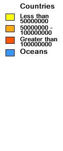
|
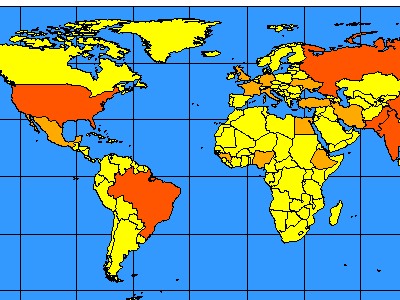
|
| Change in initial ENVELOPE: |
|
<?xml version="1.0" encoding="UTF-8"?> <ARCXML version="1.1"> <CONFIG> <ENVIRONMENT>...</ENVIRONMENT> <MAP> <PROPERTIES> <ENVELOPE minx="-13.0" miny="36.0" maxx="34.0" maxy="69.0" name="Initial_Extent" /> <MAPUNITS units="decimal_degrees" /> </PROPERTIES> <WORKSPACES>...</WORKSPACES> <LAYER>...</LAYER> </MAP> </CONFIG> </ARCXML> |

|
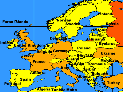
|
|
| Example viewer configuration file: |
|
<?xml version="1.0" encoding="UTF-8"?> <ARCXML version="1.1"> <CONFIG> <ENVIRONMENT> <LOCALE country="US" language="en" variant="" /> <UIFONT color="0,0,0" name="Arial" size="12" style="regular" /> <SCREEN dpi="96" /> </ENVIRONMENT> <MAP> <PROPERTIES> <ENVELOPE minx="-178.0" miny="12.89" maxx="-68.0" maxy="83.59" name="Initial_Extent" /> <MAPUNITS units="decimal_degrees" /> </PROPERTIES> <WORKSPACES> <IMAGESERVERWORKSPACE name="mapper_ws-6" url="http://mymachine.domain.com/servlet/com.esri.esrimap.Esrimap" service="background" /> <FEATURESERVERWORKSPACE name="ifs_ws-7" url="http://mymachine.domain.com/servlet/com.esri.esrimap.Esrimap" service="states" /> <AVIMSWORKSPACE name="av_ws-6" url="http://mymachine.domain.com/servlet/com.esri.esrimap.Esrimap" view="Roads" map="roads21204240" /> <MOIMSWORKSPACE name="mo_ws-4" url="http://mymachine.domain.com/scripts/esrimap.dll" service="GPS_Points" /> <SHAPEWORKSPACE name="shp_ws-8" directory="<path to CANADA ESRIDATA" /> </WORKSPACES> <LAYER type="image" name="Background" visible="true" id="0"> <DATASET name="background" type="image" workspace="mapper_ws-6" /> </LAYER> <LAYER type="featureclass" name="States" visible="true" id="1"> <DATASET name="2" type="polygon" workspace="ifs_ws-7" /> <SIMPLERENDERER> <SIMPLEPOLYGONSYMBOL boundarytransparency="1.0" filltransparency="1.0" fillcolor="255,255,153" boundarycaptype="round" /> </SIMPLERENDERER> </LAYER> <LAYER type="featureclass" name="Provinces" visible="true" id="2"> <DATASET name="province" type="polygon" workspace="shp_ws-8" /> <SIMPLERENDERER> <SIMPLEPOLYGONSYMBOL boundarytransparency="1.0" filltransparency="1.0" fillcolor="127,27,27" boundarycaptype="round" /> </SIMPLERENDERER> </LAYER> <LAYER type="image" name="Roads" visible="true" id="3"> <DATASET name="mymachine.domain.com:roads21204240:Roads" type="image" workspace="av_ws-6" /> <IMAGEPROPERTIES transparency="0.80" /> </LAYER> <LAYER type="image" name="GPS Points" visible="true" id="4"> <DATASET name="mymachine.domain.com:GPS_Points" type="image" workspace="mo_ws-4" /> </LAYER> </MAP> <OVERVIEWMAP backgroundcolor="255,255,255" framefillcolor="255,0,0,80" frameoutlinecolor="255,0,0" zoomfactor="4.0"> <LAYERDEF name="States" /> <LAYERDEF name="Provinces" /> </OVERVIEWMAP> <SCALEBAR backcolor="212,208,200" fontcolor="0,0,0" mapunits="decimal_degrees" scaleunits="feet" screenunits="inches" /> </CONFIG> </ARCXML> |
| Using IMAGESERVERWORKSPACE: |
|
<?xml version="1.0" encoding="UTF-8"?> <ARCXML version="1.1"> <CONFIG> <ENVIRONMENT>...</ENVIRONMENT> <MAP> <PROPERTIES>...</PROPERTIES> <WORKSPACES> <IMAGESERVERWORKSPACE name="mapper_ws-6" url="http://mymachine.domain.com/servlet/com.esri.esrimap.Esrimap" service="background" /> </WORKSPACES> <LAYER type="image" name="Background" visible="true" id="0"> <DATASET name="background" type="image" workspace="mapper_ws-6" /> </LAYER> </MAP> <OVERVIEWMAP>...</OVERVIEWMAP> <SCALEBAR ... /> </CONFIG> </ARCXML> |
| Using FEATURESERVERWORKSPACE: |
|
<?xml version="1.0" encoding="UTF-8"?> <ARCXML version="1.1"> <CONFIG> <ENVIRONMENT>...</ENVIRONMENT> <MAP> <PROPERTIES>...</PROPERTIES> <WORKSPACES> <FEATURESERVERWORKSPACE name="ifs_ws-7" url="http://mymachine.domain.com/servlet/com.esri.esrimap.Esrimap" service="states" /> </WORKSPACES> <LAYER type="featureclass" name="States" visible="true" id="1"> <DATASET name="3" type="polygon" workspace="ifs_ws-7" /> <SIMPLERENDERER> <SIMPLEPOLYGONSYMBOL boundarytransparency="1.0" filltransparency="1.0" fillcolor="255,255,153" boundarycaptype="round" /> </SIMPLERENDERER> </LAYER> </MAP> <OVERVIEWMAP>...</OVERVIEWMAP> <SCALEBAR ... /> </CONFIG> </ARCXML> |
| Map configuration file used in the Feature Service: |
|
<LAYER type="featureclass" name="States" visible="true" id="3"> <DATASET name="STATES" type="polygon" workspace="shp_ws-1" /> <SIMPLERENDERER> <SIMPLEPOLYGONSYMBOL boundarytransparency="1.0" filltransparency="1.0" fillcolor="255,255,153" boundarycaptype="round" /> </SIMPLERENDERER> </LAYER> |
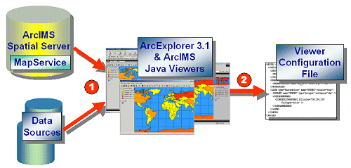
| Viewer configuration file: |
|
<LAYER type="featureclass" name="States" visible="true" id="1"> <DATASET name="3" type="polygon" workspace="ifs_ws-7" /> <SIMPLERENDERER> <SIMPLEPOLYGONSYMBOL boundarytransparency="1.0" filltransparency="1.0" fillcolor="255,255,153" boundarycaptype="round" /> </SIMPLERENDERER> </LAYER> |
| Default viewer configuration file: |
|
<LAYER type="featureclass" name="States" visible="true" id="1"> <DATASET name="2" type="polygon" workspace="ifs_ws-7" /> <SIMPLERENDERER> <SIMPLEPOLYGONSYMBOL boundarytransparency="1.0" filltransparency="1.0" fillcolor="255,255,153" boundarycaptype="round" /> </SIMPLERENDERER> </LAYER> |
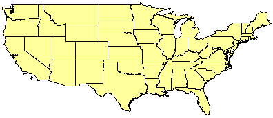
|
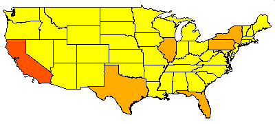
| After layer rendering has been changed in the viewer configuration file: |
|
<LAYER type="featureclass" name="States" visible="true" id="1"> <DATASET name="2" type="polygon" workspace="ifs_ws-7" /> <VALUEMAPRENDERER lookupfield="POP1999"> <RANGE lower="482025" upper="11351422" label="Less than 11351422"> <SIMPLEPOLYGONSYMBOL boundarytransparency="1.0" filltransparency="1.0" fillcolor="255,255,0" boundarycaptype="round" /> </RANGE> <RANGE lower="11351422" upper="22220818" label="11351422 - 22220818"> <SIMPLEPOLYGONSYMBOL boundarytransparency="1.0" filltransparency="1.0" fillcolor="255,170,0" boundarycaptype="round" /> </RANGE> <RANGE lower="22220818" upper="33090215" label="22220818 - 33090215"> <SIMPLEPOLYGONSYMBOL boundarytransparency="1.0" filltransparency="1.0" fillcolor="255,85,0" boundarycaptype="round" /> </RANGE> </VALUEMAPRENDERER> </LAYER> |
|
| Using AVIMSWORKSPACE: |
|
<?xml version="1.0" encoding="UTF-8"?> <ARCXML version="1.1"> <CONFIG> <ENVIRONMENT>...</ENVIRONMENT> <MAP> <PROPERTIES>...</PROPERTIES> <WORKSPACES> <AVIMSWORKSPACE name="av_ws-6" url="http://mymachine.domain.com/servlet/com.esri.esrimap.Esrimap" view="Roads" map="roads21204240" /> </WORKSPACES> <LAYER type="image" name="Roads" visible="true" id="3"> <DATASET name="mymachine.domain.com:roads21204240:Roads" type="image" workspace="av_ws-6" /> <IMAGEPROPERTIES transparency="0.80" /> </LAYER> </MAP> <OVERVIEWMAP>...</OVERVIEWMAP> <SCALEBAR ... /> </CONFIG> </ARCXML> |
| Using MOIMSWORKSPACE: |
|
<?xml version="1.0" encoding="UTF-8"?> <ARCXML version="1.1"> <CONFIG> <ENVIRONMENT>...</ENVIRONMENT> <MAP> <PROPERTIES>...</PROPERTIES> <WORKSPACES> <MOIMSWORKSPACE name="mo_ws-4" url="http://mymachine.domain.com/scripts/esrimap.dll" service="GPS_Points" /> </WORKSPACES> <LAYER type="image" name="GPS Points" visible="true" id="4"> <DATASET name="mymachine.domain.com:GPS_Points" type="image" workspace="mo_ws-4" /> </LAYER> </MAP> <OVERVIEWMAP>...</OVERVIEWMAP> <SCALEBAR ... /> </CONFIG> </ARCXML> |
|
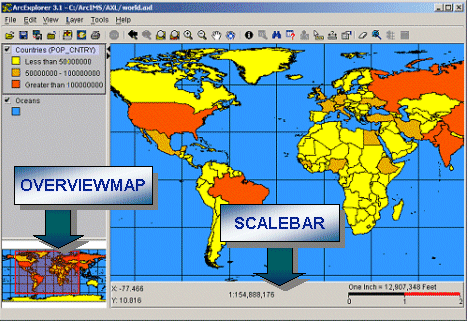
| Using OVERVIEWMAP and SCALEBAR: |
|
<?xml version="1.0" encoding="UTF-8"?> <ARCXML version="1.1"> <CONFIG> <ENVIRONMENT>...</ENVIRONMENT> <MAP>...</MAP> <OVERVIEWMAP backgroundcolor="255,255,255" framefillcolor="255,0,0,80" frameoutlinecolor="255,0,0" zoomfactor="4.0"> <LAYERDEF name="Oceans" /> <LAYERDEF name="Countries" /> </OVERVIEWMAP> <SCALEBAR backcolor="212,208,200" fontcolor="0,0,0" mapunits="decimal_degrees" scaleunits="feet" screenunits="inches" /> </CONFIG> </ARCXML> |
|
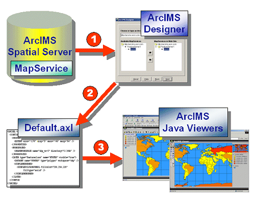
| Example default.axl file: |
|
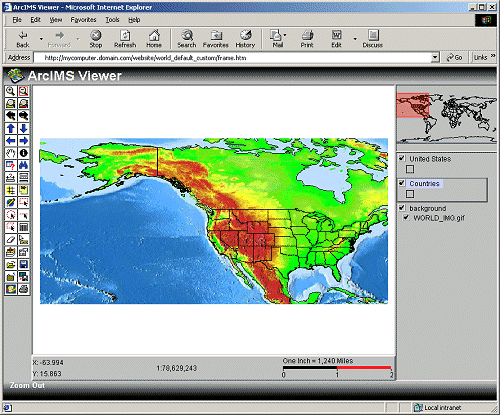
<?xml version="1.0" encoding="UTF-8"?> <ARCXML version="1.1"> <CONFIG> <MAP> <PROPERTIES> <ENVELOPE minx="-180.0" miny="-90.0" maxx="180.0" maxy="90.0" name="Initial_Extent" /> <MAPUNITS units="decimal_degrees" /> </PROPERTIES> <WORKSPACES> <IMAGESERVERWORKSPACE name="mapper_ws-6" url="http://mycomputer.domain.com/servlet/com.esri.esrimap.Esrimap" service="background" /> <FEATURESERVERWORKSPACE name="ifs_ws-7" url="http://mycomputer.domain.com/servlet/com.esri.esrimap.Esrimap" service="World" /> </WORKSPACES> <LAYER type="image" name="background" visible="true" id="0"> <DATASET name="background" type="image" workspace="mapper_ws-6" /> </LAYER> <LAYER type="featureclass" name="Countries" visible="true" id="1"> <DATASET name="0" type="polygon" workspace="ifs_ws-7" /> </LAYER> <LAYER type="featureclass" name="United States" visible="true" id="2"> <DATASET name="1" type="polygon" workspace="ifs_ws-7" /> </LAYER> </MAP> <SCALEBAR backcolor="212,208,200" fontcolor="0,0,0" mapunits="decimal_degrees" scaleunits="feet" screenunits="inches" /> </CONFIG> </ARCXML> |
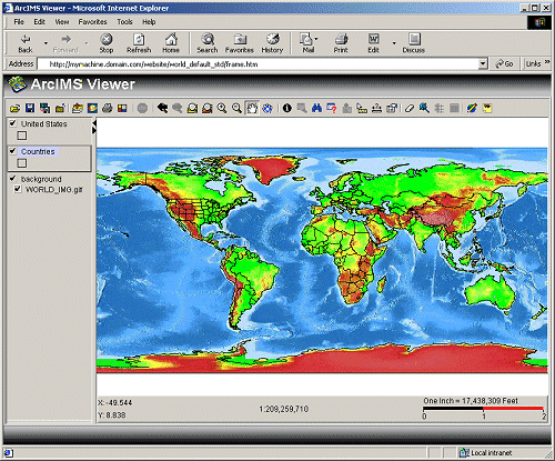
| Using ENVELOPE Initial_Extent: |
|
<PROPERTIES> <ENVELOPE minx="-180.0" miny="-90.0" maxx="180.0" maxy="90.0" name="Initial_Extent"/> <MAPUNITS units="decimal_degrees" /> <PROPERTIES> |
|
| Using ENVELOPE Initial_Extent and Extent_Limit: |
|
<PROPERTIES> <ENVELOPE minx="-61.1" miny="3.7" maxx="91.7" maxy="61.3" name="Initial_Extent"/> <ENVELOPE minx="-61.1" miny="3.7" maxx="91.7" maxy="61.3" name="Extent_Limit"/> <MAPUNITS units="decimal_degrees" /> <PROPERTIES> |
|
| Including SCALEBAR: |
|
<?xml version="1.0" encoding="UTF-8"?> <ARCXML version="1.1"> <CONFIG> <MAP>...</MAP> <SCALEBAR backcolor="212,208,200" fontcolor="0,0,0" mapunits="decimal_degrees" scaleunits="feet" screenunits="inches" /> </CONFIG> </ARCXML> |
| Map Config | Viewer Config | Default.axl | |
| Primary purpose | Used as input to ArcIMS services | Saves current map and viewer configuration on the client | Used to load ArcIMS services in an ArcIMS Java Viewer |
| Created by | ArcIMS Author or XML Editor | ArcExplorer 4 or ArcIMS Java Viewers | ArcIMS Designer |
| File is located | On server | On client | On server |
| Data sources | Local network only and must be accessible by ArcIMS Spatial Server | ArcIMS services and local network on client | ArcIMS services only |
| Valid workspaces | SHAPEWORKSPACE, IMAGEWORKSPACE, SDEWORKSPACE | IMAGESERVERWORKSPACE, FEATURESERVERWORKSPACE, AVIMSWORKSPACE, MOIMSWORKSPACE, SHAPEWORKSPACE, IMAGEWORKSPACE, SDEWORKSPACE | IMAGESERVERWORKSPACE, FEATURESERVERWORKSPACE, AVIMSWORKSPACE, MOIMSWORKSPACE |