| Attribute |
Usage |
Back to Top |
| autoextend |
Extends the legend to accommodate information for all layers. Should always be set to "true" with ArcMap Server. |
| backgroundcolor |
Legend�s background color using RGB values. |
| display |
Turns legend on or off. |
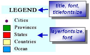
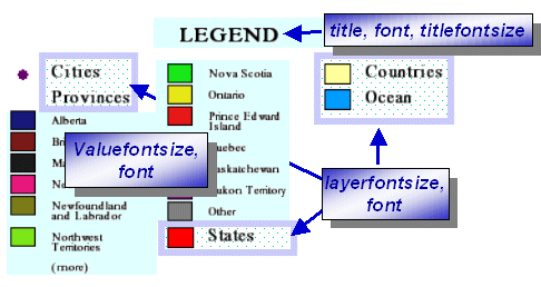
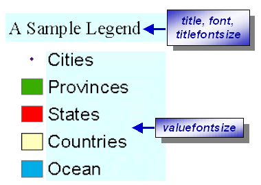
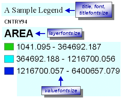
| font |
Font for title. The name is case sensitive. If font name uses "&", use "&" instead. For example, ESRI Transportation & Civic should be written as ESRI Transportation & Civic. |
| layerfontsize |
Sets the font size of the childheading for layers that include a value map. |
| swatchheight |
Height of the symbol swatch in pixels. |
| swatchwidth |
Width of the symbol swatch in pixels. |
| title |
Title of legend. |
| titlefontsize |
Font size for title. |
| valuefontsize |
For layers that include a value map, it sets the font size for value map labels. For layers with no value map, it sets the font size for the layer name. |
| Attribute |
Usage |
Back to Top |
| anitaliasing |
Used to make edges of labels and symbols smoother. When set to "true", antialiasing is active. Note that the time to generate a map may significantly increase when antialiasing is turned on. |
| autoextend |
If "true", automatically extends legend vertically past size specified in height, if needed. |
| backgroundcolor |
Legend�s background color using RGB values. |
| cansplit |
Allows splitting of valuemap layers between columns. |
| cellspacing |
Defines number of pixels to pad between entries. |
| columns |
Defines number of columns in legend. |
| display |
Turns legend on or off. |
| font |
Font for title. The name is case sensitive. If font name uses "&", use "&" instead. For example, ESRI Transportation & Civic should be written as ESRI Transportation & Civic. For Feature Services, the font must reside on the client machine or else the system default font is used. |
| height |
Legend height in pixels. |
| layerfontsize |
Font size for layer labels. |
| reverseorder |
Reverse order of layers. |
| splittext |
Text that displays in bottom of a column if a valuemap is carried over into the next column. |
| swatchheight |
Height of the symbol swatch in pixels. |
| swatchwidth |
Width of the symbol swatch in pixels. |
| title |
Title of legend. |
| titlefontsize |
Font size for title. |
| transcolor |
Transparency color using RGB values. White is 255,255,255. |
| valuefontsize |
Font size for value map labels. |
| width |
Legend width in pixels. |
| Example 4: Map configuration file where layers with ID of "0" and "1" are removed from the legend list. |
Back to Top |
<?xml version="1.0" encoding="UTF-8"?>
<ARCXML version="1.1">
<CONFIG>
<ENVIRONMENT>
<LOCALE country="US" language="en" variant="" />
<UIFONT color="0,0,0" name="Arial" size="12" style="regular" />
<SCREEN dpi="96" />
</ENVIRONMENT>
<MAP dynamic="true" >
<PROPERTIES>
<ENVELOPE minx="-180.0" miny="-90.0" maxx="180.0" maxy="90.0" name="Initial_Extent" />
<MAPUNITS units="decimal_degrees" />
<LEGEND title="Legend" font="Arial" autoextend="true" columns="1" width="170" height="300" backgroundcolor="255,255,0" >
<LAYERS>
<LAYER id="0"/>
<LAYER id="1"/>
</LAYERS>
</LEGEND>
</PROPERTIES>
<WORKSPACES>
<SHAPEWORKSPACE name="shp_ws-0" directory="<path to WORLD ESRIDATA>" />
<SHAPEWORKSPACE name="shp_ws-2" directory="<path to USA ESRIDATA>" />
<SHAPEWORKSPACE name="shp_ws-3" directory="<path to CANADA ESRIDATA>" />
</WORKSPACES>
<LAYER type="featureclass" name="WORLD30" visible="true" id="0">
<DATASET name="WORLD30" type="polygon" workspace="shp_ws-0" />
<SIMPLERENDERER>
<SIMPLEPOLYGONSYMBOL filltype="solid" fillcolor="0,153,255" />
</SIMPLERENDERER>
</LAYER>
<LAYER type="featureclass" name="CNTRY94" visible="true" id="1">
<DATASET name="CNTRY94" type="polygon" workspace="shp_ws-0" />
<SIMPLERENDERER>
<SIMPLEPOLYGONSYMBOL filltype="solid" fillcolor="255,255,153" />
</SIMPLERENDERER>
</LAYER>
<LAYER type="featureclass" name="United States" visible="true" id="2">
<DATASET name="STATES" type="polygon" workspace="shp_ws-2" />
<SIMPLERENDERER>
<SIMPLEPOLYGONSYMBOL filltype="solid" fillcolor="255,0,0" />
</SIMPLERENDERER>
</LAYER>
<LAYER type="featureclass" name="Canada" visible="true" id="3">
<DATASET name="province" type="polygon" workspace="shp_ws-3" />
<SIMPLERENDERER>
<SIMPLEPOLYGONSYMBOL filltype="solid" fillcolor="0,153,0" />
</SIMPLERENDERER>
</LAYER>
<LAYER type="featureclass" name="World Cities" visible="true" id="4">
<DATASET name="CITIES" type="point" workspace="shp_ws-0" />
<SIMPLERENDERER>
<SIMPLEMARKERSYMBOL color="102,0,102" width="8.0" />
</SIMPLERENDERER>
</LAYER>
</MAP>
</CONFIG>
</ARCXML>
|