
Page 4 - GIS for Science: GIS Response to COVID-19
P. 4
THE STORY BEHIND THE JHU COVID-19 DASHBOARD
An Interview with Dr. Lauren Gardner
In late January 2020, as the world began to fathom the magnitude of the public health crisis originating in Wuhan, China, a well-designed map began circulating on social media and then quickly found its way onto mainstream media and traditional news sites. The map was actually more of an information dashboard with statistics and charts surrounding the map itself. It drew attention with its dramatic red circles, scaled by size, that indicated the total number of COVID-19 cases and deaths. Perhaps even more important, the daily updates satisfied the desperate need for current and accurate information from a worldwide audience. At the time, the dark-themed application created by the Center for Systems Science and Engineering (CSSE) at Johns Hopkins University seemed to be the most comprehensive and reliable source of information about the spread. Innumerable dashboards to track the virus have since been created (many of which used the underlying JHU data), but the now- famous “JHU dashboard” remains the leading source of consolidated COVID-19 data as of this writing, ultimately generating hundreds of billions of total views.
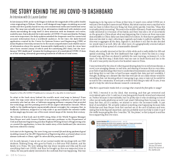
Snapshot of the JHU COVID-19 dashboard on January 22, a day after its initial launch.
So what is the back story behind the world’s most viral map in history? Puns aside, the map came about because of an interesting confluence of people at the university who had an idea, a California mapping software company that provided the technology, and the pressing need to fill an urgent information vacuum. When traffic to the dashboard grew exponentially almost overnight, the company, Esri, in Redlands, California, stepped in to help scale it up and handle the extreme traffic as this single app became one of the most viewed maps of the twenty-first century.
The editors of this book and ArcGIS Living Atlas of the World Program Manager Sean Breyer met with Lauren Gardner, associate professor in the Department of Civil and Systems Engineering at Johns Hopkins Whiting School of Engineering who co-created the application, to hear the inside story of the dashboard (the interview has been edited for clarity).
Let’s start at the beginning. You were living your normal life and doing epidemiological modeling research at the JHU Department of Engineering when you heard about a new disease outbreak in China, right? So when did this journey actually start?
LG: In early January, I was at one of our normal weekly lab meetings with our PhD students. Ensheng Dong, who goes by Frank, is a first-year PhD student, and his family is in China. We were talking that day about measles and Zika and flu and everything that’s not COVID. And then he brought up this new suspected virus in China. He was particularly interested in the outbreak that was happening. This was
beginning to be big news in China at that time. It wasn’t even called COVID yet; it was just a few hundred cases around Wuhan. My initial reaction was to say that we’re way too busy to follow this new thing, but then pretty quickly, I was like, “Okay, this is actually pretty interesting.” This was in the middle of January. Frank was personally really interested in it because of his family, and there was also a lot of uncertainty on the ground in China about what was happening. But it turns out there was some data available in China: daily case data linked to location. So that day we grabbed the data and decided to start collecting it regularly and make it publicly available. The idea was to aggregate all the data, organize it, and share it out. But we also decided we would map it as well. After all, what more of a geographically oriented subject could there be than spread of a transmissible disease?
Frank, who actually interned at Esri for a little while and is really skilled in GIS and spatial modeling, built the first dashboard that night to show the data in a map- focused way, and then we shared it publicly the next morning, on January 21, to be exact. On that first map, I think there was one case in South Korea and one in the US, and it was pretty much just a few hundred cases in China.
I was motivated by the idea of collecting and sharing data for an infectious disease, a novel, new emerging disease, in real time, and sharing it because this is a very data- poor field of epidemiology that tries to understand transmission and risk and spread, and doing that in real time is hard because usually that data just isn’t available. I thought, building out a dataset like this that we’d just do as a daily release would be something that, not knowing where it was going to go, may or may not be useful for us and for the community. It took just a week for that thing to take off. So yes, it was good to help the infectious disease research community.
Was there a particular media link or coverage that created the first spike in usage?
LG: Well, I tweeted it on the 22nd, that morning, and that got retweeted and recirculated quite a bit. I could see it was being pretty heavily viewed and retweeted on Twitter because it was trackable, but I’m pretty sure it was circulating on lots of other social media platforms as well; I just wasn’t following them because we were busy. But then, all of a sudden, we started to notice the increased traffic. It just kind of snowballed. We actually realized something was happening because Julia Holtzclaw and Sean Breyer from Esri reached out at the end of January and were saying this looks big and important, and you probably need our help to scale it up if the traffic keeps going like this. I was like, “Hi. Yes please,” so Esri jumped in and has been supporting this ever since.
xiv
GIS for Science
Lauren Gardner’s January 22 tweet about the launch of the dashboard.
