
Page 138 - Mapping the Nation: Taking Climate Action
P. 138
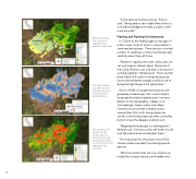
Before the Camp Fire, this mix of vegetation was present in the forest. "Some data we had was wrong," Francis said. "Being able to see it right there allows us to build knowledge and make our plan a little more accurate." Planting and Planning Simultaneously In California, the federal agency manages 15 million acres, much of which is inaccessible to crews replanting trees. There are also a limited number of seedlings, so they must be planted carefully where they will thrive. "Based on capacity, resources, and access, we can only hope to reforest about 10 percent of the Camp Fire burn scar, and that's if everyone is working together," Rempel said. "That's another place where GIS comes in handy because we have to be extremely strategic and know we're doing the right things in the right places." Much of BLM's management practices are guided by shared maps. GIS is well suited to landscape-level planning because it contains details on the topography—ridges, rock outcroppings, slopes, water, and valleys. Foresters must consider multiple factors, among them that north-facing slopes are cooler, south-facing slopes are drier, and valley bottoms have the deepest and best soils. "Mapping the landscape is a starting point," Rempel said. "It shows us what the forest should look like and what we should plant there." The map pinpoints the places that will be climate stable and ideal for planting specific species. "We know where trees live now, and we can model the climates they're comfortable with," This solar heating map denotes cool and wet versus hot and dry areas to guide planting. 137 The severity of the Camp Fire, like all fires, was not uniform. Here, red areas denote where more than 90 percent vegetation loss occurred.
