
Page 137 - Mapping the Nation: Taking Climate Action
P. 137
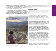
megafires have hit, including the North Complex fire that consumed 318,935 acres in 2020 and the Dixie Fire that burned 963,309 acres in 2021. Together, these fires have left few trees untouched in this corner of Northern California. "This place doesn't want to be the same forest because it's so climate challenged," said Austin Rempel, senior manager of reforestation at the nonprofit American Forests. "For instance, sugar pine is everyone's favorite tree because they grow big Wolfy Rougle of the Butte County Resource Conservation District surveys plans. Image courtesy of American Forests. and look nice, but climate models say they don't want to live here anymore. Low-elevation sugar pine is going to be a thing of the past." Assisting Tree Migration Trees can't just pick up their roots and move, and a natural migration could take centuries. It's up to foresters to plant for what the forest wants to become, a practice known as "assisted migration." "Assisted migration is a no-brainer for our organization, knowing that forests need to adapt," Rempel said. "In the Camp Fire area, because of its low elevation, it's quickly turning from dense mixed conifer forest into a place that wants to be more oak and grassland and chaparral and gray pine." Analysts at American Forests apply models that use spatial analytics to consider species tolerance and soil types, along with climate forecasts about heat and rainfall, to predict what plants will want to live in a place far into the future. This level of climate action requires a detailed map to understand what exists, the conditions best suited for each plant, and where similar conditions can be found elsewhere. GIS is used to perform this suitability analysis, with predictions that improve with more data. For the BLM's Francis and other foresters, ArcGIS Online became the place to combine data and plan collaboratively. It also provided the portability to all look at a shared map as they roamed the burn scar. "We take scientific concepts, and we look at them on the ground, and then we compare them with what we see on the map," she said. "We can scroll and look at different layers while we're walking to inform us of things that we can't readily see. Knowing the soil type is serpentine, for example, explains why those trees look scrawnier." Checking the map in the field is called ground truthing, and it provides the opportunity to adjust and add more details. 136 Wildfire
