
Page 135 - Mapping the Nation: Taking Climate Action
P. 135
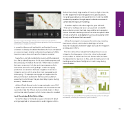
The total counts of property damage across Jackson County from the Almeda and Obenchain Fires provide sobering statistics that have motivated homeowners to harden their homes. is currently a three-month waiting list, and training for more volunteers is already scheduled. Residents who have completed an assessment gain a better understanding of general wildfire hazard concepts along with specific mitigation needed. Inspections can help residents be more mentally prepared for a fire by identifying areas of risk around their property and discussing ways to reduce those risks. Other topics covered during an assessment include receiving emergency alerts, evacuation protocols, and "go bags" and encouraging productive conversations between neighbors to enhance mitigation actions within areas that share topography and landscaping. "The people we engage with appreciate the direct conversation and tend to feel less anxious after an assessment, which means they are less likely to panic during an event," Hendrix said. Ashland Fire & Rescue is also incorporating the use of GIS in public maps to track and share where risk assessments have occurred to help fire officials and concerned citizens in these communities identify areas in which more outreach is needed. Local Knowledge Builds Better Maps One of the keys to Ashland's success is the level of detail and rigor applied to risk assessments and mitigation efforts. Rather than classify large swaths of the city at high or low risk, the fire department has leveraged GIS to capture specific risk and hazard details at the parcel level on more than 6,800 residential properties through expert curbside assessments combined with exposure modeling. Chambers explains the advantage this gives Ashland: "The wall-to-wall data we have is unusual with over 6,800 data collection points that help map wildfire risk to people's homes. We have a better picture of risk with site-specific data of fuels and homes and vegetation across a broad area within the city and the areas that surround it." Ashland's next goal is to reassess the entire city, including businesses, schools, and multiunit dwellings, to further improve the dataset and better target resources for mitigation and education efforts. That rich dataset has helped the fire department secure mitigation funding grants, inform the critical work people must conduct to make their lots and homes safer, facilitate the department's response to fires, and ultimately save more buildings and put fewer firefighters in harm's way during future wildfires. The Almeda Fire Loss and Recovery Dashboard shares a picture of damage and renewal, including the community's goal to rebuild. 134 Wildfire
