
Page 133 - Mapping the Nation: Taking Climate Action
P. 133
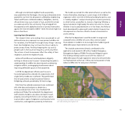
Although one Ashland neighborhood was partially evacuated when the fire began, the strong southeasterly wind spared the city from the devastation suffered by neighboring Talent and Phoenix. Ashland residents, firefighters, and city officials knew it was just a matter of luck, and the fire served as a wake-up call for the community. They emerged from the experience with added motivation to protect themselves against the next inevitable wildfire—when the winds might not blow in their favor. Learning from Devastation The verdant forest surroundings that coax people to call Ashland home also represent an ever-present wildfire risk. For residents, the Almeda Fire taught many things—among them that firefighters may not have the time or ability to protect every home. And that keeping the city and its people safe in the future will require a community effort. The actions of each homeowner affect the safety of their neighbors and entire neighborhoods. Ashland Fire & Rescue had already been diligently working on these issues for years—researching the public's understanding of wildfire risk, planning and coordinating mitigation efforts, and engaging homeowners about improving defensible space on their properties. In 2018, fire department officials went house to house doing baseline curbside risk assessments of all single-family residences in Ashland. They performed the risk assessments using Esri partner Intterra's firefighting software, powered by GIS technology. Data from the curbside assessments was combined with other data and analyses to determine a more accurate picture of risk. City of Ashland GIS professional Rickey Fite worked with fire department staff to build a model to calculate a risk level for each property, accounting for factors such as slope, aspect, road condition, types of vegetation and maturity, home construction, and vegetation proximity to the home. The model accounted for other external factors as well as the homes themselves, drawing on custom maps of all wildland vegetation within one mile of Ashland, building footprints, and a "nearby neighbor" analysis showing how a home's proximity to other homes could affect its chances of igniting. Whereas a typical calculation might apply the same risk score to a house whether it was located downtown or in the forest, the Ashland team developed this advanced model to better measure true risk exposure as a function of both a home's characteristics and its setting. After the fire department used the model to assign each assessed home a wildfire risk score, they communicated those details to residents to encourage home hardening and defensible space improvements around homes. The citywide assessments directly contributed to the application and award of a $3 million Federal Emergency Management Agency (FEMA) Pre-disaster Mitigation grant. The funding is being used to assist with the creation of defensible space through vegetation removal and wood shake roof replacement at the top 1,100 at-risk home parcels to help reduce wildfire risks for everyone in Ashland. This map shows the wildfire risk score of homes in an Ashland neighborhood, with red indicating the highest risk 132 Wildfire
