
Page 132 - Mapping the Nation: Taking Climate Action
P. 132
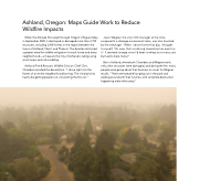
Ashland, Oregon: Maps Guide Work to Reduce Wildfire Impacts When the Almeda Fire swept through Oregon's Rogue Valley in September 2020, it destroyed or damaged more than 2,750 structures, including 2,400 homes in the region between the towns of Ashland, Talent, and Phoenix. The disaster reinforced a greater need for wildfire mitigation for each home and every neighborhood—a measure the City of Ashland is taking using smart maps and risk modeling. Ashland Fire & Rescue's Wildfire Division Chief Chris Chambers recalled the devastation. "I drove right into the flames of an entire neighborhood burning. The initial priority had to be getting people out, not putting the fire out." Jason Wegner, the city's GIS manager at the time, assigned to a damage assessment team, was also haunted by the wreckage. "When I drove home that day, I thought to myself, ‘Oh wow, that car driving toward me has paint on it.' It seemed strange since I'd been looking at so many cars burned to bare metal." But in Ashland, where both Chambers and Wegner work, only a few structures were damaged, and during the fire. many people were going about their business as usual. As Wegner recalls, "There were people hanging out in the park and walking around with their lunches, with complete destruction happening mere miles away." 131
