
Page 130 - Mapping the Nation: Taking Climate Action
P. 130
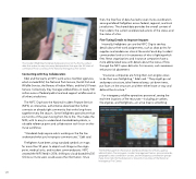
The Incident Web Map Template helps personnel on the fire line collect data that makes its way into many data products that span the full chain of command. Photo courtesy of the National Interagency Fire Center. Connecting with Key Collaborators Edel and the teams at NIFC work across member agencies, which include BLM, the National Park Service, the US Fish and Wildlife Service, the Bureau of Indian Affairs, and the US Forest Service. Collectively, they manage wildland fires on nearly 700 million acres of federal public land and support wildfire work in all other jurisdictions. The NIFC Org hosts the National Incident Feature Service (NIFS), an interactive, authoritative data feed that further connects an already tight community that works long hours together every fire season. Some firefighters spend more than six months of the year moving from fire to fire. This makes the NIFS, with its easy-to-understand standardized symbols, a valuable reference point and collaboration tool for an on-the- move workforce. "Standards help anyone who's working on the fire line understand what you're trying to communicate," Edel said. Firefighters have been using standard symbols on maps for more than 50 years to depict such things as the origin point, medical units, and incident command posts. NIFC created the NIFS feed in 2016, shifting to cloud-based ArcGIS Online so more users could access the information. Since then, the free flow of data has led to even more coordination among wildland firefighters across federal, regional, and local jurisdictions. The shared data provides the overall context of the incident, the current and planned actions of the crews, and the status of a fire. Fine-Tuning Details to Improve Impacts Internally, firefighters can use the NIFC Org to see key details about their work assignments, such as drop points for supplies and rendezvous sites at the end of each day. Incident commanders look to it for awareness of who is fighting which fires. News organizations and insurance companies have a more abbreviated view, with details about the status of fires through the NIFC open data site. For insurers, such awareness enhances risk abatement. "Insurance companies are hiring their own engine crews to do their own firefighting," Edel said. "They might go out and prep a structure, take firewood away, cut down trees, put foam on the structure, and then either leave or stay and defend the structure." For interagency wildfire operations personnel, seeing the real-time locations of fire resources—including air tankers, fire engines, and firefighters—on a live map is something The Risk Management Assistance Dashboard helps line officers, agency administrators, fire managers, incident management teams, area commands, geographic area coordinator centers, and multiagency coordination groups make more risk-informed decisions. Screenshot courtesy of the National Interagency Fire Center. 129
