
Page 131 - Mapping the Nation: Taking Climate Action
P. 131
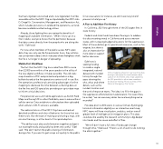
that has long been envisioned and is now legislated. It will be accessible within the NIFC Org as stipulated by the 2019 John D. Dingell Jr. Conservation, Management, and Recreation Act, which includes provisions on wildland fire operations, as funds become available and technology allows. Already, those fighting fires are seeing the benefits of mapping all available information. "When I show up on a fire in Idaho, everyone knows the fire perimeter, because that data comes directly from the people who are doing the work," Edel said. For now, when members of the public access NIFC open data, they can only see the fire perimeter. Soon, they will also see containment detail, which indicates where firefighters think the fire is no longer in danger of spreading. Mobile-First Workflows The fact that the NIFC Org has scaled from 300 to more than 22,000 users within a five years speaks to the utility of the new digital workflows it makes possible. The old static map shared as a PDF and printed and posted on a big bulletin board at the fire operations center is still in use. But fire operations professionals are taking advantage of online mapping to decrease the time between collecting data on the fire line and GIS specialists providing an up-to-date map to inform critical decisions. Fire personnel use such mobile applications as ArcGIS Field Maps and Survey123 to collect field data, even in areas without cellular service. Data and photos collected are then uploaded when cellular or Wi-Fi service is available. The administrators of the NIFC Org have worked out detailed workflows and rules of behavior for those that use these tools. But the ease of making and sharing a map, with minimal training, is at the heart of its rapid adoption. "The ability to put data and information together and get it out to people easily and quickly has been very useful," Edel said. "We don't restrict the public sharing of information during a fire. If you want to get a map out quickly to the public for an evacuation, for instance, we don't want any kind of process to hold you up." A Plan to Add More Fire History In California, 2021 brought three of the 20 largest fires in state history. Federal and state funds have been flowing in to address this disconcerting trend, in California and across western states, with increasing budget allocations for fire suppression. Most of those dollars go to operational resources, such as fire engines, but there is also an imperative for more data to support better decisions. Edel now is seeking funding to create a single integrated, national dataset with incident history through the years showing the who, what, and where details, such as the incident location and the work of response teams. The idea is to fill in the gaps in fire suppression efforts before modernization. For recent fires, he noted, "we can see every dozer line and everything we've recorded." Fire data prior to 2016 exists in various formats. By bringing historical information digitally on an interactive smart map, NIFC teams will have visualization, analytics, and an overall greater level of intelligence for mitigation plans. This data could also be used by the research community to dig deeper into trends and the cause and effect of fires. "We still don't have a full view of landscape change through time," Edel said. "There's a lot of work to do to bring the data together." Online mapping allows for near real-time data sharing to decrease the time between data capture on the fireline and a map update by the GIS specialist to other team members for decision-making. Photo courtesy of the National Interagency Fire Center. 130 Wildfire
