
Page 14 - Mapping the Nation: Taking Climate Action
P. 14
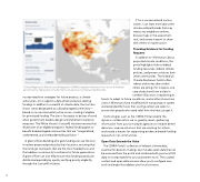
13 Climate Mapping for Resilience and Adaptation (CMRA) integrates information from across the federal government to help people consider their local exposure to climate-related hazards. If I'm a concerned and curious citizen, I can learn more about the climate-related hazards that may impact my neighbors and me, browse maps in the assessment tool, and create a report to share with others to inspire action. Providing Evidence for Funding Requests In addition to information about projected climate conditions, the portal highlights links to federal funding resources, federal climate policies, and proven solutions from other communities. The linked US Climate Resilience Toolkit offers videos and stories about what others are doing. For instance, one case study shows how a tribe in northern Wisconsin is replanting its incorporated into strategies for future projects, a climate action plan, or to support a data-driven proposal seeking funding. In addition to a wealth of climate data, the tool also shows areas designated as a disadvantaged community— based on an environmental justice score—making it eligible for prioritized funding. The aim is for equity to be top of mind when government leaders design and implement resilience measures. The White House's Justice40 initiative ensures that 40 percent of an eligible program's federal funding goes to benefit disadvantaged communities that are "marginalized, underserved, and overburdened by pollution." A grant officer deciding who gets funding can use the tool to review proposed projects by their locations, ensuring that the funds go to projects that are the most needed now and that address a community's resilience for future generations. A grant officer can also help ensure that funding awards are distributed equitably by quickly verifying priority eligibility through the Justice40 initiative. forests to adapt to future conditions, and another shows how cities in Minnesota have modified their transportation system and extended the hours that cooling centers are open to ensure that people who need relief from the heat can get it. Technologies such as the CMRA Portal enable the dynamic collaboration we so greatly need—gathering information from across multiple agencies to enable better decisions, expose solutions that are working for others, and create a means for supporting evidence-based funding requests for all communities. Open Data Extends the Value The CMRA Portal's collection of relevant climate data, essential for decision-making, also includes open data that can be accessed from the portal and combined with your local GIS data or incorporated into your assessment tools. The curated content and open data services allow you to configure new tools and maps that address your local concerns.
