
Page 141 - Mapping the Nation: Taking Climate Action
P. 141
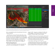
CAL FIRE uses Technosylva's Wildfire Analyst tool to understand the impacts of a fire's predicted spread. Here, you can see dots for structures on the map and a corresponding table that indicates when the fire may reach these buildings. With this detailed simulation, CAL FIRE can quickly understand the potential for the fire and make better decisions on response and suppression options. above, causing lightning strikes that sparked spot fires ahead of advancing flames. CAL FIRE officials—who say they have never seen so many acres burn with such intensity—are trying to be ready for what the state's fires will do next. Firefighters are now using imagery, smart maps, and computer simulations to monitor and forecast fire behavior. "The technology helps us understand that, without suppression, this is where the fire could go," said Phillip SeLegue, CAL FIRE's deputy chief of intelligence. Allocating Strained Resources Every day, CAL FIRE officials must continuously reprioritize resources for new and emerging fires. On a single day— August 16, 2021—the agency was fighting 10 wildfires with 10,700 firefighters, 795 fire engines, 192 hand crews, 265 bulldozers, 276 water tenders, and 45 helicopters. "Thankfully, we have a lot of resources here in California, but we also have a lot of ground to cover and people to protect," SeLegue said. Using a tool called FireGuard, CAL FIRE officials can see when and where fires spark and then create strategies to match specific needs with strained resources. FireGuard gives CAL FIRE access to video and images captured by classified US military drones and satellites as well as nonclassified imaging and weather satellites. Firefighters use the visualization tool on an hourly basis to monitor the 140 Wildfire
