
Page 171 - Mapping the Nation: Taking Climate Action
P. 171
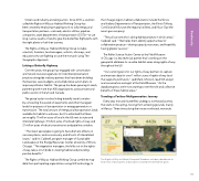
Citizens and industry are taking action. Since 2015, a coalition called the Rights-of-Way as Habitat Working Group has been creatively employing mapping tools to rally energy and transportation partners—railroads, electric utilities, pipeline companies, state departments of transportation (DOTs)—to use long, narrow swaths of land to give the butterflies flight paths with the right plants to fuel their journey. The Rights-of-Way as Habitat Working Group includes scientists, foresters, land managers, activists, attorneys, and educators who are fighting to save the monarch using The Geographic Approach. Linking a Butterfly Highway Over the years, the group has engaged with conservation and natural resources agencies to foster best preservation practices alongside industry partners that have been building the business case, budgets, and collaborative action plans to improve pollinator habitat. The group has been growing its reach, partnering with more than 400 organizations across private and public sectors in the US and Canada. The group's plan involves linking butterfly travel corridors by connecting thousands of easements and other managed lands for purposes of transportation or energy generation or transmission. The total amount of energy and transportation lands available for habitat is unknown, but it's estimated that there are roughly 17 million acres of land in the US next to state and interstate highways; 3 million acres of railroad rights-of-way; and 21 million acres of electric transmission and pipeline corridors. "The insect apocalypse is going to have dramatic effects on our ecosystems, and our economy, and all sorts of interrelated issues," said Iris Caldwell, program manager of Sustainable Landscapes at the Energy Resources Center, University of Illinois, Chicago. "The vegetation managers, the folks out on the rights- of-way, take a lot of pride in creating habitat and providing positive benefits." The Rights-of-Way as Habitat Working Group combines map data from participating organizations using GIS technology. In the Chicago region, habitat collaborators include the Illinois and Indiana Departments of Transportation, the Illinois Tollway, ComEd and NiSource (the regional utilities), and Nicor Gas (the area's gas company). "They all can see who's doing habitat projects in which areas," Caldwell said. "That helps them identify opportunities for collaborative projects—sharing capacity, resources, and hopefully having greater success." The Keller Science Action Center at the Field Museum in Chicago is a key technical partner that's working on the geospatial database to visualize habitat areas along rights-of-way throughout the US. "Our current goal is for our rights-of-way partners to capture and maintain data for over 1 million acres of rights-of-way land that supports pollinators," said Mark Johnston, lead GIS analyst and conservation ecologist at the Field Museum. "As the database grows, we're now starting to see the role and collective benefits of these habitat areas." Traveling a Perilous Multigeneration Journey Every year, monarch butterflies undergo a northward journey that starts in the spring, moving from wintering grounds, mainly in Mexico. Three times along their route northward, monarchs The Rights-of-Way as Habitat Geospatial Database includes a dashboard to keep track of participants and progress toward protected habitat goals. 170 Biodiversity
