
Page 169 - Mapping the Nation: Taking Climate Action
P. 169
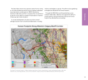
The data helps answer many questions about human activity or to isolate and remove human activity to better understand natural processes and disruptions. ABMI's Biodiversity Intactness Index does just that: it compares the concentrations of species across regions to predict the abundance of species if there was zero human footprint. In a recent development, the data may inform several subregional plans that involve broad stakeholders, including industry and Indigenous groups. The effort involves gathering more granular data about the human footprint. Through the ABMI effort and the partnerships across multiple stakeholders, Albertans have gained the ability to answer questions about biodiversity and how the human footprint has affected the surroundings. The map of the human footprint in Alberta captures agriculture, forestry, transportation, human-created water bodies, urban and industrial uses, and energy features, such as mines and wells. Image courtesy of the Alberta Biodiversity Monitoring Institute. 168 Biodiversity
