
Page 167 - Mapping the Nation: Taking Climate Action
P. 167
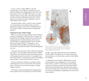
Since its inception in 2007, ABMI has captured measurements in all the different ecosystems across the province of Alberta, from the grasslands in the south to the boreal forests in the north. ABMI collects data on a range of species (plants, animals, birds, and more) and maintains records on more than 3,000 species. More than 1 million specimens have been processed, yielding discoveries of several species new to science. The resultant data is used in a variety of ways, including to formulate regional and subregional plans, evaluate development impacts, and fine-tune sustainable practices. It's also been used by local governments to guide urban expansion. Collecting the Facts to Mark Change ABMI is a scientific partnership between InnoTech Alberta, the University of Alberta, and the University of Calgary. The biodiversity work had been under way for seven years when funding came from the Alberta Ministry of Environment and Parks (AEP) to establish the Alberta Human Footprint Monitoring Program (AHFMP). The program is a joint effort between AEP and ABMI to map and monitor land transformation and assess the impact of human development over time. "There was a lot of discussion early on about how we brand the initiative," said Jim Herbers, executive director of ABMI. "Words like human disturbance would automatically alienate half the people we want to work with. So, we landed on the term human footprint. It talks about the activity, the changes to the landscape, in a value-neutral way that is inclusive." There are sensitivities in Alberta—as anywhere—about capturing the facts and not coloring them with a bias that favors or disfavors any one industry or people, including Indigenous groups. "We need to understand everything that's happening on the land surface, from natural dynamics to land-use-driven Roads and residential areas are just some of the many human land-use changes that ABMI tracks for the Alberta human footprint inventory. Image courtesy of the Alberta Biodiversity Monitoring Institute. changes," said Jahan Kariyeva, director of the Geospatial Centre at ABMI. "Although we're not making or proposing land-use decisions, we use the data to assess how the habitat has changed." Including the human footprint in ABMI's province-wide monitoring efforts meant adding data in GIS that denotes human activity—reservoirs, roads, railways, mining, timber harvesting, oil and gas, and industrial sites. Before AHFMP's creation, the human footprint was captured only for project sites and a few study areas. There was also a lack of sustained monitoring and standardization regarding what constitutes the human footprint. 166 Biodiversity
