
Page 31 - Mapping the Nation: Taking Climate Action
P. 31
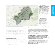
This map illustrates the protected areas (in green) as of 2021. The resultant map of the Cradle displays areas of the highest conservation value to serve as a guide to focus efforts and prioritize land purchases and conservation projects. Besides helping to formulate plans of action, the map is also a way to measure progress. As lands come under protection, the map reflects the changes. Students at the university's Interdisciplinary Geospatial Technology Lab, acting as data stewards, use the map to add to the national database of protected lands maintained by the US Geological Survey. The Power of Simple Models "What we put into this model was intentionally simplistic, but it follows years of data collection and trying to understand the data available for the region," Houser said. "Because of the complexity of the data, we recognized that we needed something simple for the model." As a visualization technology, GIS gives power to diverse stakeholders to collaborate using one cloud- based map, and the public- facing component helps the Alliance promote its work. The Cradle of Appalachia Conservation Dashboard provides a continuously updated progress report on the project. The map serves as a visually intuitive way to explain what progress means for the region. "When we share what we're doing with city planners and regional transportation organizations, the map is a key component," Reed said. "Otherwise, we're just sharing data and charts." Civic leaders in Chattanooga have applied the model to city parks, seeking out biodiversity in an urban environment. The Alliance's model and geographic approach can serve as a guide for screening conservation projects and predicting their efficacy in protecting biodiversity. Houser sees the work of Thrive and the Alliance resonating throughout Appalachia, especially as climate change and biodiversity loss force communities to adapt new strategies for environmental protection and human survival. "We're thinking about the importance of the south-to-north corridor that runs from Alabama to Maine," he said. "We're really at the base of it, the cradle. And what we do here has outsized impacts moving north." 30 to Climate Action A Geographic Approach
