
Page 43 - Mapping the Nation: Taking Climate Action
P. 43
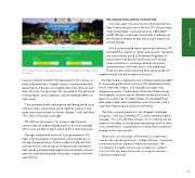
New Orleans has been expanding its parks in part to harden itself against future hurricanes. Francisco–based nonprofit that advocates for the creation of parks and preservation of green spaces—has partnered with governments in Boston, Los Angeles, New York, Denver, and other US cities. Ten years ago, TPL launched its Climate-Smart Cities program, which addresses climate-related problems in urban areas. "Parks promote health and improve well-being, build social cohesion when communities come together outdoors, and make cities more resilient to climate change," said Lara Miller, TPL's senior GIS project manager. TPL staff use GIS maps to, for instance, identify which communities are underserved by parks or how many people within a city are able to reach a park within a 10-minute walk. Through collaborative work with local governments, TPL helps cities build green infrastructure with an emphasis on climate change resilience. Projects might include new trails and transit lines, tree canopy to increase shade and reduce heat islands, parkland and playgrounds that double as flood reducers, and shoreline parks that protect coastal cities from sea level rise. The Climate Crisis and the Crescent City Just a few years into recovery from Hurricane Katrina, New Orleans became one of the first TPL Climate-Smart Cities partnerships. Causing more than 1,800 deaths and $125 billion in damage, Katrina was a harbinger of the disruptive weather events that would increase with climate change. As the city prioritized improving climate resilience, TPL facilitated the creation of "green schoolyards," replacing concrete surfaces prone to flooding with gardens of native plants that absorb rainfall and runoff. Several other interventions, including wetlands restoration and stormwater catchment basins, also addressed flood concerns while increasing open space access for neighborhoods that did not previously have it. The New Orleans collaboration set a Climate-Smart precedent for encouraging data-driven solutions. TPL developed Climate- Smart Cities New Orleans, a GIS-based tool to plan and implement projects. Climate-Smart Cities New Orleans stores and integrates location-specific datasets and projects them as layers on a smart map. For New Orleans, this included flood data, public health and household income information, and a map layer of green space access across the city. "We tailor our work based on a city's biggest challenges and goals," said Taj Schottland, TPL's senior climate program manager. "For a city like New Orleans, it's no surprise that the emphasis would be on flooding and absorbing runoff. In other cities, sometimes it's transportation or urban heat islands that emerge as the major priority." These tools not only help communities to understand risks but also guide local action. In New Orleans, "whenever someone proposes a green infrastructure project, the city requires the applicants to use our decision-support tool to justify why they want to do it in a given location," Schottland explained. 42 Extreme Heat
