
Page 46 - Mapping the Nation: Taking Climate Action
P. 46
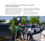
Student-Led Mapping Locates Areas in Los Angeles in Need of Shade Equity Like many US cities, Los Angeles is fighting to overcome the damaging legacy left by redlining. The practice of outlining areas with communities of color in red on maps to discourage mortgage lenders and insurance companies was banned 50 years ago, but the economic and racial segregation created by this practice persists to this day. In LA, historic redlining even affects the number of trees and resultant shade in neighborhoods, which comes with serious consequences. Recent research links redlining to lack of shade, contributing to dangerous urban heat islands. Previously redlined areas are on average 5 degrees warmer than others nationally and up to 12.5 degrees warmer in some places. Extreme heat is the top summertime killer, particularly for the elderly, and also worsens preexisting conditions such as asthma and cardiovascular disease. This is all the Source: https://www.esri.com/about/newsroom/blog/los-angeles-shade-equity/ 45 Volunteers pitch in to beautify and cool down their neighborhood. (Image courtesy of City Plants)
