
Page 53 - Mapping the Nation: Taking Climate Action
P. 53
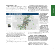
Inequity in Numbers of Trees In 1928, Austin's Master Plan (a term no longer used due to its racial connotations) relegated the city's Black communities to a district east of present-day Interstate 35. Redlining made it nearly impossible for residents to move, while it placed fewer restrictions on White residents to purchase homes in Austin's heavier-canopied parts of town. "I created the first Community Tree Priority map back in 2015, and it was really tree-planting oriented—to figure out where to plant trees," Halter said. "At that time, equity was a consideration but wasn't really the focus. We were mostly looking at where tree canopy existed and didn't exist, with the idea to increase shade across town and get trees where they're not currently located." As Halter added layers of data to the map, he saw the relationship between socially vulnerable neighborhoods and areas with minimal trees. In the wake of Black Lives Matter protests, equity became a strong focus of the Austin Climate Equity Plan, so the map needed to change. "We released an update in 2020 with equity as the driving force," Halter said. "We're now looking at tree planting to achieve positive outcomes for people, such The targeted efforts of the Community Tree Priority Map aim to address past inequities. The 1950s locked in environmental injustices when the planning commission zoned all east Austin property as "industrial," adversely affecting nearby residents with the area's lower air quality, higher temperatures due to a lack of tree cover, and other health-related issues. This common pattern is found throughout the world—the prevailing winds, blowing west to east, bring pollution to the eastern parts of town. When Halter first mapped Austin's trees, he was focused on the city council's urban forest plan. as improved public health; reduced heat island effects; and, of course, addressing climate change because it's related to everything." To understand the impacts of having fewer trees, the city participated in an urban heat island mapping project coordinated by the federal government's National Integrated Heat Health Information System, a collaboration between the National Oceanic and Atmospheric Administration (NOAA) and the Centers for Disease Control and Prevention (CDC). "Volunteers drove different routes in their cars with fancy devices poking out of their windows that recorded temperatures every few seconds," Halter said. "Using GIS, we 52 Extreme Heat
