
Page 59 - Mapping the Nation: Taking Climate Action
P. 59
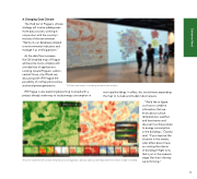
A Changing Data Climate The third tier of Prague's climate strategy will involve adding even more data sources, working in conjunction with the country's ministry of the environment. "We'll join our databases related to environmental indicators and manage it as one big project." As the data flow increases, the GIS-enabled map of Prague will become more complex with a multiplicity of applications. Looking toward Prague's carbon- neutral future, city officials are discussing with IPR Prague the possibility of rooftop photovoltaic and wind power generation. IPR Prague is also exploring becoming involved with a project already under way to study energy consumption in GIS data and maps—including extreme heat analysis municipal buildings. In effect, this would mean expanding the map to include and model indoor spaces. A tool to examine both surface temperature and vegetation density side by side helps determine where shade is needed. "We'd like to figure out how to combine information that we know about surface temperatures, weather, and heat waves and discover how these relate to energy consumption in the buildings," Čtyroký said. "If you improve the situation in the streets, what effect does it have on cooling the interior of buildings? Right now, that's just in the research stage. But that's the way we're thinking." 58 Extreme Heat
