
Page 65 - Mapping the Nation: Taking Climate Action
P. 65
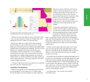
The maps produced by Land IQ relate the water use across space and time—or each crop— including almonds, which are notoriously thirsty trees. extensive in-person verification and focusing in detail on three key agricultural counties in California, ground zero for the water crisis. It's also where many of the country's almonds, apricots, dates, figs, kiwi fruit, nectarines, olives, pistachios, prunes, and walnuts are grown as well as much of the nation's avocados, grapes, lemons, melons, peaches, plums, and strawberries. Only Florida produces more oranges. Kimmelshue and Heilmann said they saw a need for scientific support in agricultural water use when they started Land IQ in 2007. Remote sensing and geospatial technology have been at the heart of what they've done, from the beginning. The California Almond Board has "We have to have those high accuracies," Kimmelshue said. "If you can save 5 percent of water over 100,000 acres, we're talking about millions of dollars of value each year." Because the stakes are so high, Land IQ does extensive ground truthing. Its crop scientists drive more than 15,000 miles across the state each year to calibrate and independently validate results for mapping crops statewide. The work involves affirming, for example, that an area of land that sensors indicated was a field of strawberries is in fact strawberries and not lettuce. The team uses a location-aware survey app powered by GIS on tablets, pinpointing that, yes, those are indeed cherries on the left and alfalfa on the right, as they log every crop they drive past—more than 12 percent of the total number of fields in the state. "The days of agricultural land-use anonymity, or any land-use anonymity, are over," Kimmelshue said. Going Where the Need Exists NASA has also gotten into the evapotranspiration business, launching OpenET to track water use in 17 western states. But Land IQ doesn't see encroachment on what it does best: been a customer for 12 years, and Land IQ's GIS-powered maps show the shifting almond crop over time. The California Department of Water Resources also hired the company to map every field across the state, with the data available publicly online. Land IQ's owners expect agricultural water use to remain a focus for them going forward, although they're acutely aware of circumstances that would require them to shift their attention, just as they did several years ago with drought conditions worsening. Even before the Sustainable Groundwater Management Act stood up strict new regulations and drought declarations were made, the company's leaders had already decided to take a more empirical approach to its wateruse data gathering. They saw the need for even greater accuracy. People's livelihoods were, and still are, on the line. That's when they incorporated more remote sensing into their approach, bridging spatial sciences and land-based sciences. Just like growers, "we just have to be nimble," Kimmelshue said. 64 Drought
