
Page 66 - Mapping the Nation: Taking Climate Action
P. 66
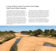
In One of Earth's Driest Countries, Smart Maps Help Protect Water Supplies Ninety-one percent of South Africa's land is at risk of becoming desert. The sense of urgency is palpable among conservationists working to improve water management practices in the diverse and majestic Kruger to Canyons Biosphere Region. The biosphere comprises 10 percent of the republic's land, yet it provides more than half of its water. Rivers, streams, wetlands, and other catchments in this 6.1-million-acre ecosystem are under pressure. Worsening droughts, pollution from human activity, and encroachment of invasive plants have diminished water quality and volume. A nonprofit company, Kruger to Canyons (K2C), is rallying residents and businesses to work together to protect the nation's waterways. Using GIS technology—including digital maps that mark the location of resources—K2C has created a library of scientific data as evidence of changing conditions in this ecosystem. The maps and data also serve as a compelling source of truth as the nonprofit works to build consensus among residents and businesses around the need for better resource management, more sustainable practices, and disaster risk reduction. "If we don't act now, we're all really going to feel it 20 years down the line," said Romy Antrobus Wuth, stewardship ecologist with K2C. "For this landscape to stay as beautiful as it is, where we all love to live, we all need to work together." 65
