
Page 72 - Mapping the Nation: Taking Climate Action
P. 72
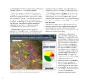
and map the data. The intent is to deliver safe water throughout the region in a way that's consistent and equitable. "Layers of complexity sometimes lend themselves to mapping, such as chemical contaminants," England said. Another issue is the need for some communities to create their water boards, she said. "That's a harder characteristic to map, but we are able to review technical and some managerial needs through a scoring system and represent that on a map." Maps will be shared with government representatives, community members, groundwater sustainability agencies, and private businesses. England worked with Gavin O'Leary, senior GIS specialist for Provost & Pritchard Consulting Group, a firm that specializes in civil, environmental, and agricultural engineering. O'Leary started by assessing available data from previous efforts in the region, stored in static reports. "The goal was to create something that can live on in time," O'Leary said. "We wanted to make the information more alive and more useful. Once you show somebody data, and they understand what they are looking at, it turns into other questions and may point out a problem somebody didn't know they had." Maps Need Data Before O'Leary and his team could create comprehensive maps for visualizing the Tulare Lake Basin water supply data, they needed more information—about wells, small water systems, off-the-map communities, and all things that are water related in the southern Central Valley. 71 Communities were ranked from a high level of need (in red) to a low level of need (in green) based on their economic classification, water quality, and water supply issues. The team could add all relevant data to the GIS for mapping, sharing, and analysis. O'Leary accessed an Esri basemap showing high-resolution aerial imagery and combined public data from local municipalities and state agencies. Then, he worked on creating a data layer for all communities in the project area, which included most of Tulare, Kern, Kings, and Fresno Counties. For communities not designated by the US Census, he needed data that was not publicly available—information that could come only from local knowledge. The project team created community surveys asking residents about their water and septic or sewage systems. Some responses came in electronically, others had to be collected by going door-to-door with the help of Self-Help Enterprises, a community development organization and project partner.
