
Page 75 - Mapping the Nation: Taking Climate Action
P. 75
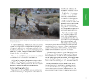
NDOW seeks to balance the mule deer's precarious position. Cody McKee, a biometrician and elk and moose specialist at NDOW, has been working on streamlining data collection, management, and analysis for several years. He was tasked with gathering historical aerial survey data from spreadsheets and filing cabinets and realized that NDOW needed to modernize its workflow for greater efficiency. Previously, biologists would take notes and jot down GPS points while in the helicopter, and then back in the office they would spend a lot of time typing data into spreadsheets and then merging data and fixing transcriptions errors. NDOW estimates that biologists were spending half the time they spent in flights to get the data usable, so if they spent 1,500 hours flying, it would take an added 750 hours before the data could be analyzed. "Helicopters are an important part of what we do, for that bird's-eye view of the landscape that gives our biologists a holistic perspective," he said. "It's also a dangerous part of our job, and at least for me, the question 'Is this the last time I get into this ship?' is always in the back of my mind. We need to be sure that we are making the most of our time in the air." McKee contacted Esri to fit the capabilities of ArcGIS Survey123 and ArcGIS QuickCapture to create one app on one device for the aerial surveying task and save time looking down instead of forward, where hazards lie. The group worked through iterations to greatly improve what With increasing pressures from drought and reduced habitat, mule deer are increasingly found where wildlands merge with urban areas. To understand the status of the species and to allocate the number of hunting tags to manage herd sizes, NDOW uses helicopters to tally numbers, gender, age, and health of the mule deer. Until recently, the surveys involved logging data on paper while in the air and often not being able to analyze or visualize the data until much later. "Now, we can see right away where deer are concentrated and where we have conflict areas," Schroeder said. NDOW gathers population details and conducts analysis using GIS technology that allows the agency's biologists to understand wildlife and ecosystem health. The data supports decisions to address the ongoing mule deer decline. Confronting Changing Conditions Advancements in the way NDOW conducts aerial surveys allow for real-time analysis of populations and conditions as 74 Drought
