
Page 80 - Mapping the Nation: Taking Climate Action
P. 80
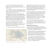
The IHS team used GIS to map and share construction progress on new water access locations. Many of these locations are at or near chapter houses, which serve as county- level governments. "We were able to collect data in all 110 chapters with just six surveyors, covering an area the size of West Virginia in just two weeks," said Captain David Harvey, deputy director, Division of Sanitation Facilities Construction at IHS. Immediate Short-Term Actions to Improve Water Access Through the GIS data collection efforts, the CARES Act funds supported the installation of 59 new transitional water point (TWP) connections to existing public water systems; supplied 37,000 water storage containers; distributed 3.5 million water disinfection tablets; and subsidized the water for people living in homes with no piped water through February 2023. The data that Clapp and the team collected helped identify locations for needed facilities. It set in motion additional mobile work to design each access point, calculate construction costs, and place orders for the right amount of pipe needed to make new connections. The fast-paced construction lasted from mid-July through September 2020. It was guided and communicated through shared maps and plans at each step of the way. An online interactive map marked progress for each chapter. In addition to the online map, a regularly updated map appeared in tribal newspapers because the paper is the primary source of information for many homes. "We were changing colors on the map, based on whether or not there was an identified transitional water point for each chapter," said Captain Shari Windt, engineering consultant, Environmental Health Support Center at IHS. The map changed when water points were slated for construction, the design was being done, the construction was complete, and the water point was open. A final color was used when a chapter had all the interventions available. The map guided the workers and the people they were serving to the new TWPs. Using GIS analysis, IHS calculated that the travel distance dropped from 52 to 17 miles, saving people an average of 38 minutes behind the wheel for each trip. Supplying Off-the-Grid Resources Just as the water access work ended, the Navajo Nation Department of Water Resources (DWR) contacted IHS under a separate request to help bridge the gap for remote homes without access to a piped water connection. DWR requested that IHS provide detailed design project drawings for a water cistern and on-site wastewater disposal facilities. The IHS deployed 15 commissioned corps engineers and environmental health officers of the US Public Health Service to undertake data collection. "The cistern project is really beneficial because you can have bathrooms with showers and toilets and sinks in kitchens," Clapp said. "The homeowners still have to haul water, but it's a bridge to more sustainable services such as a connection to a piped water system." 79 This map shows the status of water access for each chapter in the Navajo Nation.
