
Page 81 - Mapping the Nation: Taking Climate Action
P. 81
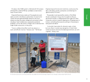
The data in the STARS system combined with GIS analysis allowed IHS to identify 900 top candidates and provide a map of those homes. Clapp led three teams made up of five people who each spent a month in the field on assessments. For each home visited, the team gathered design data from the site to determine where the water storage tank and sewer facilities should go. Team members also assessed any potential problems, such as the location of large rocks or obstacles that might hinder construction or site access. "It was a collaborative effort, and it was done in a quick and efficient manner," Hawasly said. "The Navajo Engineering and Construction Authority could access the data collected to quickly create plans and drawings for approximately 70 homes." This pandemic work spurred the creation of the Water Access Coordination Group, which includes four Navajo government entities, six federal government agencies, three universities, and two nonprofit organizations. Bringing water to homes is something that everyone working on these projects feels passionate about. "It shouldn't have taken this disaster to get us here; but now, there's a whole new recognition of what tribal resilience means and how the federal government can work together," Harvey said. A new water access point, now fully operational, was added near the Rock Springs Chapter house. (Image courtesy Indian Health Service) 80 Drought
