
Page 91 - Mapping the Nation: Taking Climate Action
P. 91
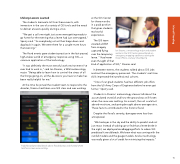
Lifelong Lessons Learned The students learned a lot from these events, with immersion in the use of a variety of GIS tools and the need to deliver answers quickly during a crisis. "We got a call one night just as we were getting ready to go home for the evening that a levee had just overtopped," Sperry said. "So everybody just set their bags down and dug back in again. We were there for a couple more hours that evening." The flood events gave students practice in the fast-paced, high-stakes world of emergency response using GIS—a common application of the technology. "It was definitely the most stressful work environment I've ever had to work in," said Ian Stearns, a WIU meteorology major. "Being able to learn how to control the stress of all the things going on, all the decisions you have to make has been really helpful for me." At the time he joined the student team to respond to the disaster, Stearns had taken one GIS class and was working at the GIS Center for three months in a paid position that gives students real-world experience. The GIS team created a DEM from imagery captured flying over the temporary levee. "I had never even thought of that kind of application of GIS," Stearns said. Ian Stearns, a meteorology major and student worker in the GIS Center, gained hands-on emergency mapping experience during the flood. (Photo courtesy Chad Sperry) In between events, the students talked about GIS jobs and met the emergency personnel. The students' real-time skills impressed their professional cohorts. "One of our grad students had two different job offers from the US Army Corps of Engineers before he even got home," Sperry said. Students in Stearns' meteorology classes talk about the accumulated snowfall and how the ground was still frozen when the snow was melting. As a result, the soil could not absorb moisture, and spring brought above-average rains. These factors contributed to the historic flood. Despite the flood's severity, damages were less than anticipated. "We had eyes in the sky and the ability to predict and not just react. Instead of waking up to find that a levee broke in the night, we deployed sandbagging efforts to where GIS predicted it would break. We knew what was coming with the rainfall models and the gauge models. And so technology was really given a lot of credit for minimizing the impacts." A dashboard provided details about flooded areas and showed where task force crews were working. 90 Inland Flooding
