
Page 108 - Mapping the Nation: Taking Climate Action
P. 108
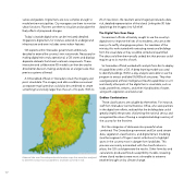
107 valves and gaskets. Digital twins are now complex enough to model entire municipalities. City managers use them to monitor urban functions. Planners use them to visualize and analyze the likely effects of proposed changes. Today's citywide digital twins can be intricately detailed. Singapore's digital twin, for instance, extends to underground infrastructure and even includes some indoor features. GIS experts within Grenada's government ambitiously decided to extend the country's twin nationwide. Necessary for making digital twins truly operational, a GIS stores and displays disparate datasets that share locational components. These interactive and collaborative 3D models can then be used to drive better decision-making and policies at a larger scale than previous systems allowed. A GIS enabled officials in Grenada to stack the imagery and point cloud data. The imagery and data could be consumed as separate map layers but could also be combined to create something functionally larger than the sum of its parts. With its Airborne lidar over Grenada produced elevation maps that were then analyzed to determine areas most susceptible to landslides (colored in red). 20 cm resolution, the resultant aerial imagery produced a data- rich, detailed representation of the island. Linking the 3D lidar data brings the imagery into full relief. The Digital Twin Goes Deep Government officials ultimately sought to use the country's digital twin to improve the lives of its residents, who are at the mercy of a swiftly changing ecosystem. For members of the ministry, this work started with extracting streets and buildings from the visual data so they could be sorted and quantified. The data could then be manually coded, but that process could require up to six months of work. So Grenadian officials worked with analysts from Esri to deploy AI capabilities within a GIS. A deep learning model was used to identify buildings. Within a day, analysts were able to use the program to extract and label 55,000 built structures. They then used geospatial artificial intelligence (GeoAI) capabilities to sort and classify other parts of the digital twin's visual data, such as roads, powerlines, streams, and other inland bodies of water, along with vegetation and land cover. Endless Combinations These classifications are valuable by themselves. For instance, staff from Grenada's Central Statistics Office, who were partners in the digital twin efforts, realized that the building data could greatly simplify the process of planning the national census and recognized the value of having a complete building inventory of the country for the first time. But the categories of data were also powerful when combined. The Grenadian government and Esri used stream data, vegetation classifications, and digital terrain modeling (another segment of Fugro's aerial collections) to highlight spots in the country most in danger from landslides. This process was mainly automated: with the classifications in place, the GIS could generate the results. Other formulas and calculations produced flood susceptibility models, revealing where island residents were most vulnerable to extreme weather brought on by climate change.
