
Page 109 - Mapping the Nation: Taking Climate Action
P. 109
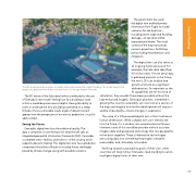
The 3D model provides a means to model and visualize potential coastal flooding. This model depicts the impact of a projected two-meter sea level rise in St. George Harbor, Grenada. The government has used the digital twin and bathymetry information from Fugro to model scenarios for sea level rise— including storm surge and flooding damage—to see what will be impacted and where. The visual context of the map transcends numeric projections, facilitating policy making for prevention and mitigation. The digital twin can also serve as an ongoing historical record. For example, the lidar data identified 4.5 million trees. If more aerial data is gathered at points in the future, the twin's GIS can analyze tree growth and note any significant deforestation. As important as the AI capabilities are for this kind of The 3D nature of the lidar data further contributed to the use of Grenada's new model. Seeing how far a building or road is from a landslide-prone area is helpful. Having the ability to zoom in and examine how a building is perched on a steep hillside or how a vulnerable road's angle of descent would appear from the perspective of a motorist, pedestrian, or cyclist adds context. Seeing the Future Grenada's digital twin has a foundational quality. The data it comprises is now the basis for what the UN calls an integrated geospatial information framework (IGIF). It provides a complete view—realistic and holistic—of the country, which supports decision-making. This digital twin also has a predictive component that allows officials to visualize future challenges posed by climate change, along with possible solutions. calculation, they wouldn't have been possible without the lidar-enhanced imagery. Grenadian planners, interested in growing the country sustainably, can now look at a section of the map and imagine how further development will impact— and be impacted by—future changes in vegetation. The value of a GIS-powered digital twin is that it enhances human observation. While a digital twin can't literally see into the future, it is a window into several potential futures. However, none of this would be possible without accurate imagery data and geospatial technology that ties geographic information together. These collaborative technologies are turning data into something meaningful; viewable; measurable; and, ultimately, actionable. Working toward sustainability goals of their own, other countries will likely follow Grenada's lead, building location- intelligent digital twins of their own. 108 Coastal Flooding
