
Page 111 - Mapping the Nation: Taking Climate Action
P. 111
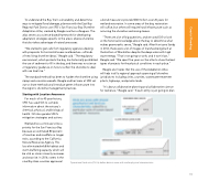
To understand the Bay Trail's vulnerability and determine ways to mitigate flood damage, planners with the East Bay Regional Park District use SFEI's San Francisco Bay Shoreline Adaptation Atlas, created by Beagle and her colleagues. The atlas serves as a science-based framework for developing adaptation strategies specific to the area's diverse shoreline that also takes advantage of natural processes. "We started to get calls from regulatory agencies dealing with proposals for horizontal levees and beaches—all kinds of new living shoreline ideas," Beagle said. "The regulatory environment, which protects the bay, has historically prohibited the use of sediment to fill in the bay, and there was no science or regulatory guidance on how to soften the shoreline to deal with sea level rise." The standard method has been to harden the shoreline using riprap and concrete seawalls. Beagle and her team at SFEI set out to share methods and introduce green infrastructure into the region's shoreline management practices. a bond measure to provide $500 million over 20 years for wetland restoration. In some areas of the bay, restoration will suffice, but others will require hard infrastructure such as armoring the shoreline and raising levees. "There are a lot of big questions, and we used GIS to look at the historical knowledge about the bay to determine what makes geomorphic sense," Beagle said. After Hurricane Sandy in 2012, there were a lot of images of marshes being built at the bottom of Manhattan despite the deep water with high wave energy. "That's not going to work, and it won't last," Beagle said. "We spent five years on the atlas to show the best types of projects for the physical conditions in each place." Beagle also hopes that the use of the Adaptation Atlas will help instill a regional approach spanning all shoreline jurisdictions including cities, counties, wastewater treatment plants, highways, and private lands. "It's about collaborative planning and collaborative science for resilience," Beagle said. "If each entity is just going to plan Starting with Location Awareness For much of its 40-year history, SFEI has used GIS to compile information about the estuary's chemical, physical, and biological health. GIS also guides SFEI's mitigation strategies and actions. Wetland loss continues to be a priority for the San Francisco Bay because an estimated 80 percent of marshes and mudflats no longer exist, according to the California Natural Resources Agency. This loss eliminated wildlife habitat and storm-buffering capacity, which will be vital as storm intensity increases and seas rise. In 2016, voters in the nine Bay Area counties approved Operational land units (OLUs) define distinct areas with similar physical characteristics. 110 Coastal Flooding
