
Page 113 - Mapping the Nation: Taking Climate Action
P. 113
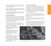
that have eaten away the marsh. The work also captured an area with a degrading levee that caused the beneficial expansion of a mudflat. By using imagery to observe and analyze natural processes, SFEI teams can guide strategy and measure the performance of different management practices. "Imagery also helps us gauge the amount of sediment that we need to supply the marshes so they can keep up with climate change," Hale said. Accommodating Differences The Bay Area is home to a diversity of people, topography, tidal patterns, and microclimates. Strategies that work in one city for one stretch of shoreline may not work in a neighboring city. The Adaptation Atlas took the approach of cataloging and describing the 30 distinct operational land units of San Francisco Bay's 400-mile shoreline. "We look at what makes sense for the land use that's existing and for what could be there in the future," Beagle said. "The Adaptation Atlas gives us a framework within which we can work using operational landscape units that are based on our understanding of the underlying geology and geomorphology." From Cleaner to Climate Ready From the 1850s to the 1960s, parts of San Francisco Bay were filled in to create land for housing and infrastructure. A lot of homes sit on land that's built from artificial fill, which poses problems in this earthquake-prone area. Wreckage from the catastrophic 1906 earthquake was simply dumped into the bay and surrounding marshland. Some homes even sit on former garbage dumps. "They used to talk about how bad the bay smelled," Beagle said. "Then with the environmental movement and changes in laws, you could no longer fill the bay, and we began cleaning it up." While nobody can yet claim that the bay is clean, years of remediation have improved water quality and restored vital habitat. "Now, it's less about fixing the problems of the past and more about how we prepare ourselves for the future," Beagle said. "We don't want to wind up with seawalls everywhere. It's about how to have a shoreline that's still ecologically functioning, accessible to people, and equitable." Modeling the processes at play helps SFEI tackle the bigger question of how to improve climate resilience while maintaining functional ecological and hydrologic systems. "By using big spatial metrics, we work to understand how high and wide certain features need to be to knock down waves in each location," Beagle said. That knowledge is then modeled against sea level rise projections to devise adaptation strategies. The Adaptation Atlas includes a map of areas identified as suitable for polder management and many other adaptation measures. 112 Coastal Flooding
