
Page 115 - Mapping the Nation: Taking Climate Action
P. 115
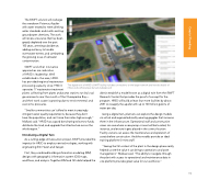
The SWIFT solution will recharge the overdrawn Potomac Aquifer with water treated to meet drinking water standards and match existing groundwater chemistry. The work will renew a resource that has been greatly depleted over the past 100 years, arresting subsidence, adding resiliency to handle stormwater events, and combatting the growing issue of saltwater contamination. SWIFT and other innovative approaches are indicative of HRSD's leadership. Well established in the area, HRSD has provided regional wastewater processing capacity since 1940. It operates 17 wastewater treatment plants collecting from pipes and pump stations run by local governments near the mouth of the Chesapeake Bay— and their work scope is growing due to environmental and economic pressures. "Smaller communities can't afford to meet increasingly stringent water quality requirements, because they don't have the population, and can't raise their rates high enough," Malkawi said. "HRSD has a good bond rating to borrow funds, distribute the load, and upgrade the infrastructure across the whole region." Introducing a Digital Twin As a cutting-edge climate action project, SWIFT provided the impetus for HRSD to employ new technologies, working with engineering firm Hazen and Sawyer. First, they combined building information modeling (BIM) designs with geographic information system (GIS) maps, workflows, and analysis. Together BIM and GIS data helped the The digital twin of HRSD's SWIFT facility includes connections to the larger network and reveals details of inflow and outflow pipes buried underground district establish a model known as a digital twin from the SWIFT Research Center that provides the proof of concept for the program. HRSD will build at least four more facilities by about 2031 to resupply the aquifer with up to 100 million gallons of water per day. Using a digital twin, planners can explore the design models via virtual and augmented reality wearing goggles that immerse them in the infrastructure. Operational staff and construction crews can see where a new pump or asset will be located, for instance, and ensure it gets placed in the correct location. Facility owners can assess the maintenance and operation of assets before construction. And the models provide an ideal training platform for new staff. "Seeing the full context of the plant in the design phase really helped us see the value it can bring to operations and asset management," Malkawi said. "The ability to navigate through the plant with access to operational and maintenance data in one platform provides great value for our workforce." 114 Coastal Flooding
