
Page 116 - Mapping the Nation: Taking Climate Action
P. 116
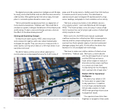
The digital twin provides operational intelligence with 3D data for newly constructed facilities and can offer the same service for older facilities. After gathering real-time sensor data, the team plans to automate systems based on sensor input. "We've achieved the standard value from our digital twin of more situational awareness," Malkawi said. "We would like to simulate our system, looking at the behavior of the infrastructure and knowing, if I open a valve and change a process, what are the effects to the downstream process?" Sensing and Examining Changes To help ensure water quality, HRSD crews test private and commercial irrigation wells near where treated water recharges the aquifer. They use sensors to measure shifts in water quality, syncing sensor data on a GIS map where it can easily be monitored. The district takes a similar, sensor-driven approach to monitor pressure and pumpperformance for its 651 miles of pipes and 131 pump stations. Staffers watch their GIS interface to examine assets at every location. The data feeds an operational principal investigator (PI) dashboard with a map, sensor readings, and graphs to track variables such as salinity. "We have conductivity meters on the different sections of our gravity system," said Jules Robichaud, GIS manager, HRSD. "The historical data is one click away. In areas at high risk for sea level rise, we're trying to get a sense of where high salinity may be an issue." When storms hit, the HRSD team reduces wastewater overflows and monitors infrastructure. With increasing storm intensity and the compounding factors of subsidence and sea level rise, there's greater urgency to protect wastewater drainage systems from spills. For this effort, the district has leaned on its GIS and digital twin technology. "We have to make over a billion dollars of infrastructure investments," Malkawi said. "We have a consent decree 115 The model includes attribute details that can be explored and queried for the complex interior of the facility. with the US Department of Justice and the EPA that we have to meet certain targets to reduce or eliminate sanitary sewer overflows to a certain rain event level. Incorporating risk into the digital twin is going to be a huge value." Modern GIS for Operational Intelligence The district has relied on GIS for many years to support day- to-day operations. In addition to smart maps and dashboards, GIS provides analytics to help HRSD meet growing infrastructure management needs. "Our operators have GIS at their fingertips to navigate to linear assets
