
Page 112 - Mapping the Nation: Taking Climate Action
P. 112
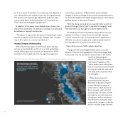
for its own piece of shoreline, it's not going to be effective, it won't be resilient, and it doesn't have any ecological benefit. The poorest communities get left behind, and the richest communities pay to build themselves out of sea level rise. That's what we see happening right now." In addition to the equity issues Beagle raises, there is the reality that nature does not operate according to jurisdictional boundaries or the built environment. "The idea is to capture the processes of watersheds, creeks, and the shoreline to plan holistically," Beagle said. "Another way to think about it is nature's jurisdictions." Imagery Deepens Understanding SFEI collects many layers of information about the bay, estuary, and watersheds, and it acts as a state spatial data center. All bay restoration projects are entered into SFEI's EcoAtlas to be tracked over time by regulatory agencies monitoring compliance. SFEI purchases aerial and lidar imagery to monitor change and accurately measure elevations. For more thorough or immediate imagery analysis, the institute deploys drones to key areas of interest. "With the drone, we're able to survey right after a storm or return at the right time of year to see what's changing," said Pete Kauhanen, GIS manager and drone expert at SFEI. The flexibility of the drone platform allows SFEI to monitor sediment volumes in stream channels and tidal marshes, monitor restoration sites, and capture harmful algal blooms. SFEI also uses drone imagery and a sophisticated machine learning algorithm to count and monitor trash. Many drone missions fulfill multiple objectives. "Flying over the Corte Madera Marsh allows us to see patterns of erosion or progradation of the marsh edge, and at the same time, we can see the state of trash in the marsh," The OLUs map shows the OLUs ringing San Francisco Bay alongside the expected sea level rise. said Tony Hale, program director of the Environmental Informatics Program at SFEI. "We're able to look at both the built environment and the natural environment and will continue to look back at the record to what has changed." SFEI's drone team also assisted with the institute's Resilient Landscapes Program in quantifying the impact of winter storms. High-resolution drone imagery and tools that automatically calculate volume provided an accurate measure of sediment and its movement. The Resilient Landscapes team analyzed the imagery to identify erosion and the surge channels 111
