
Page 110 - Mapping the Nation: Taking Climate Action
P. 110
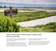
109 How an Atlas of San Francisco Bay Is Helping Deal with Sea Level Rise Recent flooding along one of America's great estuaries—the San Francisco Bay—prompted local groups to take action against further climate risk. The San Francisco Bay Trail provides more than 350 miles of walking and cycling paths through the 47 cities and nine counties that ring the San Francisco Bay. The trail acts as a popular viewing platform for tide cycles and abundant wildlife. Because it sits at the wetland-urban interface, the trail is extremely vulnerable to sea level rise. "In the San Francisco Bay, we have a long history of wetlands and ecosystem restoration for habitat conservation," said Julie Beagle, former senior scientist in the Resilient Landscapes Program at the San Francisco Estuary Institute (SFEI).
