
Page 120 - Mapping the Nation: Taking Climate Action
P. 120
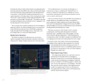
the potential impacts while meteorologists are developing the hurricane advisory. The NWS's Sea, Lake, and Overland Surges from Hurricanes (SLOSH) model doesn't have the granularity or resolution of the ADCIRC model that researchers run on supercomputers or the data inputs of the consequence model. "Even with a supercomputer, it takes approximately 90 to 120 minutes to run the model," Michell said. "That doesn't provide the National Weather Service sufficient time to integrate it into the development of their advisory." The more granular model fits perfectly with the emergency response mission. To make the details easy to consume and share, Mitchell and the team from SDMI deliver detailed maps through ArcGIS StoryMaps stories, share data, and print large maps to convey actionable details. Models Inform Operations The SDMI consequence model pinpoints a hurricane's impact on people, homes, businesses, hospitals, and critical infrastructure—details of great importance to first responders. "The model presents an overview of damages in a manner that is easy to understand," Mitchell said. "It serves as a decision-making tool on whether to call for evacuations and where to prioritize post-disaster actions such as search and rescue." In the case of Hurricane Laura, the ADCIRC and consequence model saved a lot of needless work when it showed that storm surge wasn't likely inside the city of Lake Charles. With Hurricane Laura designated a Category 4 Hurricane, the NWS warned residents of Louisiana of the potential of up to 20 feet of flooding and life-threatening storm surge. "We have an armory in Lake Charles, which is used as a staging area, and they were talking about relocating those resources," said Mike Liotta, GIS manager, a civilian with Louisiana's Military Department. "After looking at the consequence model, I was able to update our leadership that our staging area should not be impacted by the storm surge." Having the maps and models of the projected damage also helped troops stage the right equipment for cleanup and stand down the search and rescue mission. It typically takes 24 hours to completely switch missions, but thanks to the predictive view, the 225th Engineer Brigade was ready to go. Maps Support Impact Areas GIS outputs take the form of a real-time common operating picture (COP) within an emergency operations center (EOC) in which both Mitchell and Liotta can be found during an emergency. Staff with phones or tablets in the field use apps to collect and sync much of the data that a COP displays. The team also uses GIS to plot outputs of the high-resolution model onto large maps for boots-on-the-ground first responders who often work in off-the-grid areas without communication signals. 119 ComTrac provides a live view of the status of supply missions, with real-time vehicle tracking to show the location of each delivery truck. The app is built using Dashboards, which ingests GPS signals from phones to provide an automatic vehicle locator.
