
Page 121 - Mapping the Nation: Taking Climate Action
P. 121
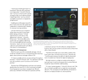
"I like having something printed in my hand when I leave the office and head to an impact area," Colonel St. Romain said. "I can lay it on the hood of a vehicle and really study it and understand where Ineedthingstobe.Iuseitasakindof sand table to maneuver our equipment and personnel." Huddling around the paper map with a pen in hand continues to be a great way to collaborate in a shared context. However, it's never just one map and done. Colonel St. Romain was an engineer officer within the ranks for many years before taking command. "I've had opportunities to work with our GIS department in the past," Colonel St. Romain said. "I know what Mike Liotta and his team are capable of delivering. If I'm not comfortable with the incoming information, I reach out to him to reinforce a decision or provide me with more details of an area I'm concerned about." Taking Care of Consequences After Hurricane Laura left considerable damage, Colonel St. Romain shifted his focus to a long-lasting and far-reaching debris removal exercise and again relied on GIS. "If I had an available vehicle, we were utilizing it throughout the event," Colonel St. Romain said. "Our operations spanned from the southwest coast of Louisiana to the northern parishes." The team from SDMI deployed a real-time truck-tracking dashboard at the state EOC to inform and reassure leaders that all equipment was where it needed to be. Mitchell, previously a member of the National Guard and currently This dashboard displays the state's COVID-19 cases and contacts detail with data from the National Hurricane Center (NHC) and from LSU's supercomputer that runs an advanced storm surge model called ADCIRC. The goal of the dashboard is to provide emergency managers with an overview of the state's COVID population. a lieutenant colonel in the Army Reserves, designed what's known as the ComTrac system to track resources as they move after a major disaster. "The National Guard moves commodities, whether it be food, water, tarps, and other vital resources," Mitchell said. "ComTrac gives everyone the ability to identify where each truck is located once it leaves the regional staging area." The high-resolution confidence model and the ability to track resources in real time have given the Louisiana National Guard new inputs for better understanding. "It's never a guessing game," Colonel St. Romain said. "We rely on the best available tools to make the most educated decisions. The consequence model definitely reinforced our decisions to readjust and pivot to certain parishes." 120 Coastal Flooding
