
Page 119 - Mapping the Nation: Taking Climate Action
P. 119
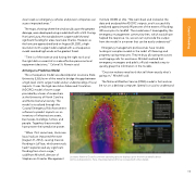
clear roads so emergency vehicles and power companies can access impacted areas." The maps, showing where the wind would cause the greatest damage, were developed using models built with a GIS. During Hurricane Laura, the standard storm surge model showed significant flooding for areas near Lake Charles. However, as the hurricane approached land on August 28, 2020, a high- resolution storm surge model coupled with a consequence model revealed high winds as the greatest threat. "Time is of the essence and having the right tools and the right data is essential to make effective personnel and equipment decisions," Colonel St. Romain said. Arriving at a Predictive Model The consequence model was developed at Louisiana State University (LSU), born of the need to bridge the gap between a high-level storm surge model and an understanding of local impacts. It uses the high-resolution Advanced Circulation (ADCIRC) model of storm surge provided by a team of researchers at the University of North Carolina and Notre Dame University. The model is visualized through the Coastal Emergency Risk Assessment software to predict impacts on an inventory of infrastructure assets, businesses, buildings, homes, and people. Together, these models have proven their predictive power. Institute (SDMI) at LSU. "We went back and looked at the data and analyzed the ADCIRC outputs, and it successfully predicted approximately 90 percent of the extent of flooding 48 hours prior to landfall. The model wasn't leveraged by the emergency management community then, which would have helped the response. So, we set out to provide the output from the model in a manner that can be easily understood." Emergency management professionals have trouble looking at complex models in the midst of lifesaving and property-saving measures. They're busy allocating resources and triaging calls for assistance. Mitchell realized that emergency managers and public officials needed a way to quickly grasp the information in the models. "Decision-makers need tools that tell them exactly what's going on," Mitchell said. The National Weather Service (NWS) model is fast and can be run on a desktop computer. Speed is crucial to understand "When I first came here, Hurricane Isaac had just impacted the state \[August 21, 2012\], causing massive flooding in LaPlace, which previously hadn't experienced any significant flooding from storm surge," said Brant Mitchell, director of Stephenson Disaster Management Louisiana National Guard's common operating picture displays up-to-the-minute details about storms and operations. Here, the projected wind force is viewed with other details. 118 Coastal Flooding
