
Page 156 - Mapping the Nation: Taking Climate Action
P. 156
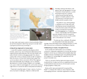
155 Pairs of Bewick's (pronounced like "Buick") wrens can be seen in dry thickets and open woods in the west. The Bewick's wren is found in abundance and is considered a species of least concern for facing extinction. air, clean water, open space, access to food, and shelter. When we see their populations declining, we have to wonder what's causing that and how we can remedy it." A Data-Driven Approach to Conservation In late 2018, Audubon established the Migratory Bird Initiative, and its focus was multifaceted: identify places that migratory birds need and protect the ones that matter most, reduce threats to birds, and engage people from diverse communities in the joy of birds and the wonder of migration. With this mission in mind, Smith and her team asked: How can we use data to drive conservation efforts? By mapping when and where birds face challenges, such as suburban development or climate change, Audubon can investigate root causes of decline and engage with communities and local organizations to reverse the decline and preserve biodiversity. Presented using three types of maps—species, locations, and conservation challenges—Explorer combines bird banding, tracking, abundance, and genetic data with geography. Intricate illustrations of each species, a custom basemap built by Esri, and well- crafted storytelling help Explorer appeal to multiple audiences, from conservationists and advocates to birders and the casually curious. The platform's eye-catching design is fueled by troves of data that were identified, processed, and published to ArcGIS Online. Each of the partners listed on the Explorer home page provided aggregations of migration science. Tracking data was the exception because individual scientists owned that information. And to secure it, Smith and her team contacted each one of them. The data was then combined in Movebank, an online platform that helps researchers manage, share, and analyze animal-tracking information. In total, 283 institutions have contributed to Bird Migration Explorer. Collaborating to Create a Complete Picture Smith worked with staff members across Audubon, contractors, and partner organizations to ensure that the bird migration science was accurately and meaningfully depicted. Audubon Director of Enterprise GIS Connor Bailey facilitated the integration of cutting-edge GIS capabilities with the project's broader vision. "Early on, we had to find the right technology and work closely with Esri to make sure that our underlying infrastructure could handle the immense amount of information we were bringing together," Bailey said. Bailey and his team partnered with Esri partner Blue Raster—a company that creates an array of dynamic web and mapping solutions—and other organizations to build a
