
Page 158 - Mapping the Nation: Taking Climate Action
P. 158
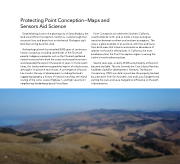
Protecting Point Conception—Maps and Sensors Aid Science Despite being close to the growing city of Santa Barbara, the land around Point Conception, California, is wild enough that mountain lions and bears hunt on the beach. Biologists say it feels like turning back the clock. Archaeological work has revealed 9,000 years of continuous human occupancy, including sacred sites of the Chumash people. Indigenous peoples such as the Chumash gathered natural resources from both the ocean and coastal mountains and stewarded the area for thousands of years. In more recent times, this land somehow escaped the imprint of infrastructure, although it's had some near misses. A convergence of factors has stood in the way of development, including the land's rugged topography, a history of livestock ranching, the inland routing of the iconic coastal Highway 1, and high security for neighboring Vandenberg Space Force Base. Point Conception sits where the Southern California coastline bends north, and so marks a major ecological transition between northern and southern ecoregions. The area is a great example of an ecotone, with flora and fauna from both areas that intermix and create an abundance of species not found in other places. In California, the most biodiverse state, the Point Conception region is among the nation's most biodiverse places. Several years ago, a nearly 25,000-acre property at the point became available. The site, formerly the Cojo-Jalama Ranches, had been slated for development. However, The Nature Conservancy (TNC) was able to purchase the property, backed by a donation from Esri founders Jack and Laura Dangermond, putting the Jack and Laura Dangermond Preserve on the path of preservation. 157
