
Page 160 - Mapping the Nation: Taking Climate Action
P. 160
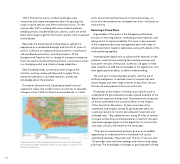
159 TNC's first priority was to conduct landscape-scale inventories and create management plans for grazing, fire, roads, invasive species, and other necessary factors. On the science side, TNC is working with many research partners wielding sensors, handheld devices, drones, and more of the latest technology to gather information quickly to be visualized and analyzed. Reynolds, the lead scientist at the preserve, applies his experience as a vertebrate biologist and from his 21 years of work in California on migratory bird and salmon conservation, oak woodlands restoration, and other projects. At the Dangermond Preserve, he's in charge of a research enterprise that's focused on biodiversity preservation, conservation action in a changing world, and climate change adaptation. Kelly Easterday leads conservation technology at the institute, working closely with Reynolds to apply GIS to streamline operations, facilitate research, and record knowledge about the preserve. During her doctoral work, Easterday paired historical vegetation maps with modern forest inventories to describe changes across California forests and woodlands. In similar The preservation of this large parcel protects an area that allows free movement of wildlife along the California coast. Map courtesy of The Nature Conservancy. work, documenting the preserve's historical ecology—to know how the preserve has changed over time—has been an early priority. Restoring a Prized Place A good deal of the work on the Dangermond Preserve focuses on restoring habitat, combating invasive species, and taking action to improve habitats. This work is documented in the integrated resources management plan with maps of where restoration needs to take place, along with details of the methods being applied. Leveraging the digital twin to advance their research on the preserve, scientists are analyzing the natural processes and ecosystem services of the place. Scientists use apps for field data collection to add their knowledge to the digital twin, and then apply spatial analytics to derive understanding. The work also involves big data analysis, with the aid of artificial intelligence, to decode troves of camera trap and drone images and other large volumes of data from sensors that record measurements from across the site. Freshwater at the reserve is limited, and scientific work to understand the groundwater provides a good example of the digital twin approach being used. The preserve encompasses an entire watershed, from coastal shallows to the heights of the Santa Ynez Mountains. To learn more about the watershed, hydrologists turned 22 groundwater wells into a sensing network to monitor groundwater movement and recharge rates. They added sensors along 50 miles of streams to reveal surface flows and temperatures. Data from the wells and stream gauges pipes into the digital twin to monitor the vital signs critical to the health of the landscape. "The sensors and research partners give us an incredible opportunity to understand how a fractured rock coastal watershed operates," Reynolds said. The mix of sensors and GIS provides near real-time readings and informs long-range planning. The knowledge of changes to groundwater will help
