
Page 161 - Mapping the Nation: Taking Climate Action
P. 161
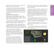
adaptation plans at the preserve and prove useful in other Mediterranean-type coastal ecosystems. Easterday and her team are focused on developing early warning systems for the region to help them understand how climate is changing and impacting species distributions. "It's a place where we can develop some of the tools to be more proactive instead of reactive about climate pressures," Easterday said. Establishing a Point of Preservation Researchers from diverse disciplines are drawn to the preserve's eight miles of wild coastline as well as its diverse habitats of chaparral, grassland, oak woodlands, coastal scrub, dunes, and closed-cone pine forests. So far, scientists have counted 200 species of wildlife and nearly 600 plant species. "Whenever researchers visit and do fieldwork, we expand the species list," Reynolds said. The data gets added to GIS to provide the digital twin of the preserve. Researchers add to it, and the open nature of the digital twin allows them to plug in their own research and influence others while everyone gets a greater understanding. The institute has been collaborating with Indigenous communities to incorporate traditional land management practices where possible. Practices such as prescribed burning have proved effective for reducing fire intensity while enhancing the quality of the landscape for culturally important plant species. To date, the inventories have largely been on land, but marine inventories are under way i to create land–sea connectivity in the face of climate change. The structure of the marine-protected area off the coast and the mix of cold water from the north with warm water from the Santa Barbara Channel yield the diversest surfperch community in California. Also, the Point Conception State Marine Reserve is a protected area of 22.52 square miles, where no living marine resources may be taken. The preserve is focused on protection. Access points nearby include the Jalama Beach County Park, but the preserve is largely off-limits to the general public. In the future, access will be managed through docent-led hiking tours and volunteer opportunities. That gives wildlife free reign, and it enables scientists, land managers, and Indigenous partners to see the land in its natural state and witness how a native coastal ecosystem works. Elsewhere along the California coast are efforts to restore connectivity for wildlife. But in this place, everyone can see and understand what natural connectivity means because the flow of species is unfettered across diverse habitat types. Many discoveries have been made in the few years this wild property has been available for science, and more are certain to come. "This landscape has a really powerful narrative to tell us in this moment in human history, and we're excited to tell these stories," Reynolds said. Mobile workflows feed a dashboard that keeps track of trees planted and protected in the oak restoration project. Screenshot courtesy of The Nature Conservancy. 160 Biodiversity
